Andrew Van Slyke chased the frontier. Born in New York in 1797, he first went to Illinois, where he met and married his wife, Electra Norton in 1824. Leaving the Northwest Territory in the 1830s, he traveled with his family to southwest Missouri. Then in the early 1840s, he moved south into Arkansas and then finally, gone to Texas prior to 1848 to claim land provided to settlers as part of what would be called the Peters Colony.

Markups done by the blog author
The lands are pretty equally divided between woodland and prairies, with a gently undulating surface, and is interspersed with rivers, rivulets, and fine springs, which afford, at all seasons of the year, a superabundance of the purest and most wholesome water. The forest trees consist principally of white, post, and Spanish Oak, pecan, cottonwood, ash, elm, black walnut, and holly, affording an abundant supply of timber for fuel, building and all agricultural purposes.
The Arkansas Banner
Little Rock, Arkansas | 08 Jan 1845, Wed | Page 3

Peters Colony
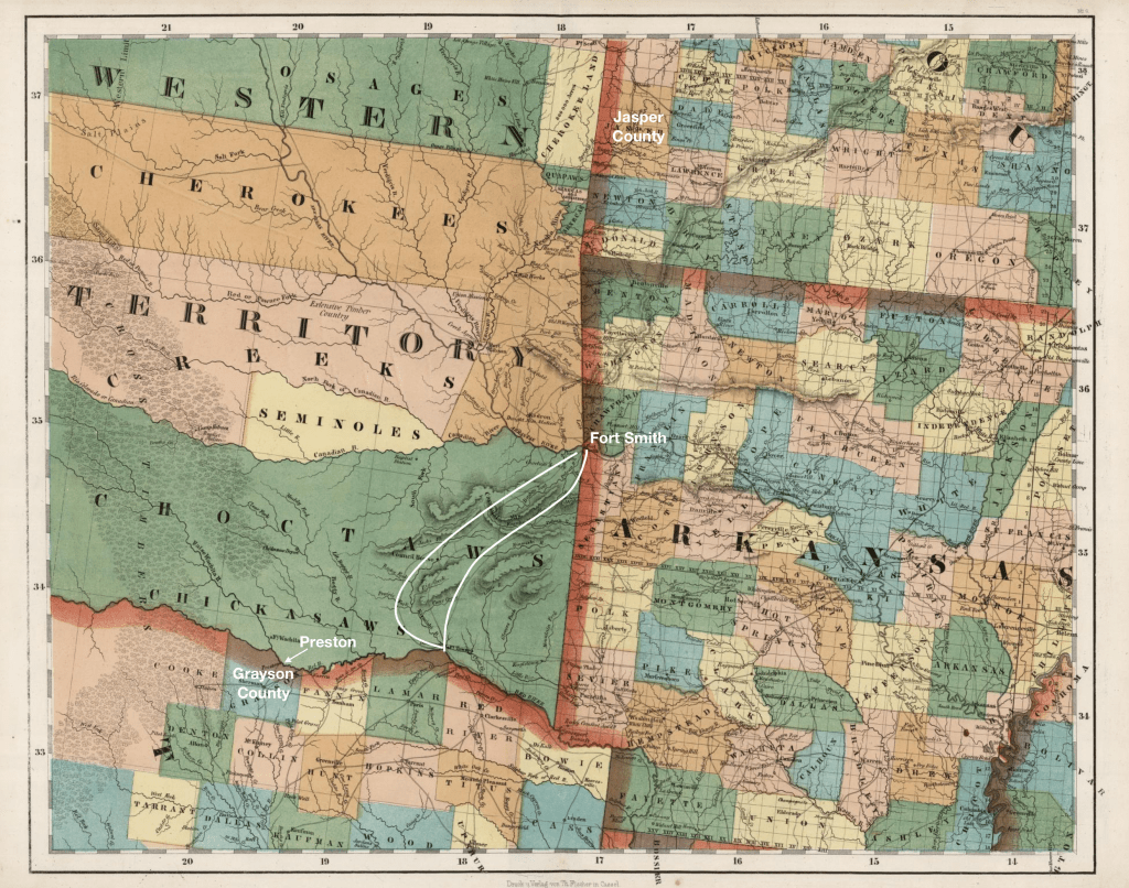
The Peters Colony was established under the Spanish system of empresarios. The leaders of the colony were granted the right to recruit and attract settlers to the “vacant lands of the Republic.” The lands were between the Brazos and Red River, and included the “celebrated Cross Timbers” along the upper Trinity River. Set up during the Republic of Texas, the leaders of the colony were granted a large swath of northern Texas and they advertised heavily in Illinois, Missouri, and Arkansas for settlers. Settlers from Arkansas were advised to come to Fort Smith and then to Fort Towson and from there to Inglish’s Fort. (Arkansas Banner, 8 Jan 1845)
Military Road
The road from Fort Smith to Fort Towson passed through the Indian Territory, where the US had removed several Indian nations from the east. It was built in the 1830s and connected frontier forts. It was approximately 145 miles long. A letter to the editor in 1839 extolling its virtues described it as a “veritable turnpike” with the assurance of “an excellent road at all seasons.” (Weekly Arkansas Gazette, 10 Jul 1839)
Fort Smith was established purposely to enforce US control over the Indian nations: the local Osage Indians and the Cherokee who had been forcibly resettled in the Indian Territory as well as the resettled Choctaw, Seminole, Chickasaw and Muskogee Indians. The frontier forts were established by the US War Department after the Black Hawk War when the resettled nations of Fox and Saux had tried to return to their ancestral lands in what the US claimed as Illinois.
Fort Towson was also established in the 1820s to serve as an outpost between the US and then Mexico, and later the Republic of Texas. During the Mexican War, it served as a staging post. It was abandoned in 1854 as the frontier “moved” west.
Coffee’s Station and Inglish’s Fort
Coffee’s Station was on the Red River, and was a trading post established by Holland Coffee in the 1830s. The trading post, along the Red River, was a place where Indigenous people and Anglo-Americans exchanged goods, the Indigenous people bringing furs for rifles, ammunition and guns. Later, in the vicinity of his post, Coffee established the town of Preston.

South of Coffee’s Station, was Inglish’s Fort, another military outpost on the Frontier. When the land was organized by Anglo-Americans into Fannin County, the settlement was renamed Bonham and established as a county seat.

One thought on “Andrew Van Slyke | Gone to Texas”