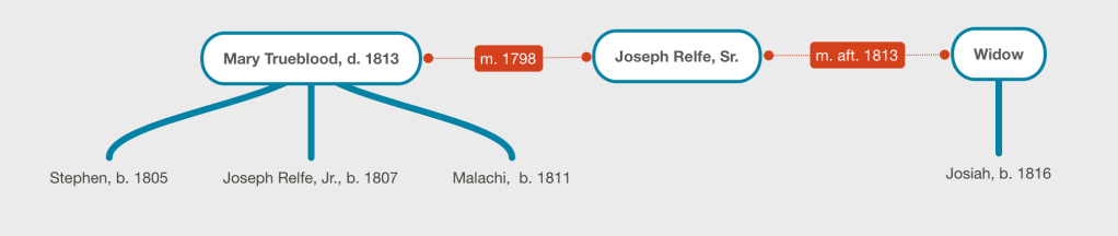
Joseph Relfe died in 1818, leaving an estate in debt, a widow, and four “infant” boys, Stephen, Joseph, Malachi and Josiah. In this case, the “infant” boys are merely under 21 years of age.
Many family histories located on the web and in ancestry.com list Joseph Relfe’s wife as Mary Trueblood with a son, Joseph, born about 1808. The histories omit the other sons, Stephen, Malachi and Josiah. Additionally, they list Mary’s death date as 1813, which is prior to the birth year of Josiah, suggesting that Joseph remarried after Mary’s death and that Stephen, Joseph and Malachi are half-brothers to Josiah. A review of the Joseph Relfe Estate Files in the familysearch.org database “North Carolina Estate Files, 1663-1979” provides clues that allow us to identify the next wife and widow of Joseph Relfe who is the mother of Josiah Relfe.
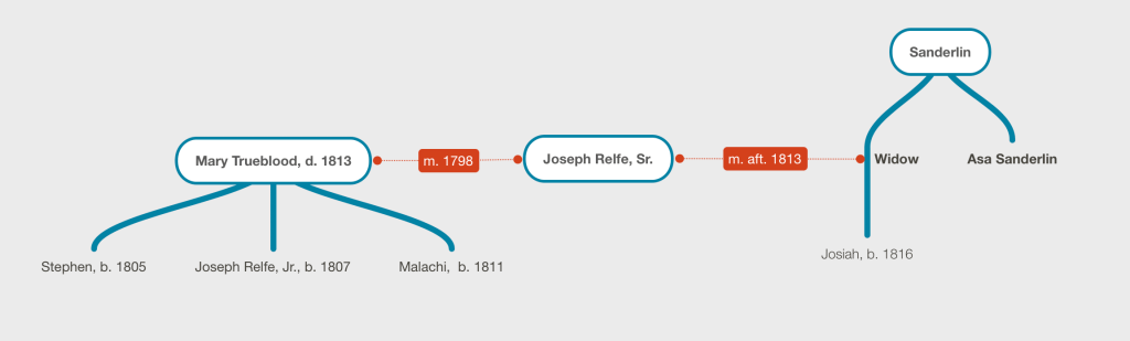
Asa Sanderlin, Uncle
The estate first named “Asa Sanderlin” as the administrator of the estate. Petitions included in the estate file refer to him as the “uncle and good friend” of the orphans: Stephen, Joseph, Malachi, and Josiah as he seeks a partition of land for his nephews. (Image 32). The land is partitioned and provides the orphans land upon which the old courthouse sat (Enfield or Winfield).
John Winslow, Step-Father
Asa Sanderlin died in 1819, the role of administrator of the estate was transferred to John Winslow who was named “administrator de bonis non”. (Image 22). He makes several petitions to the court to sell property and chattels to cover the debts of the estate.
In 1821, the court detailed the division and valuation of the enslaved Black individuals held by Relfe’s estate. John Winslow, “in right of his wife, Sarah, who was the widow of Joseph Relfe” received a fifth-share of the valuation, with the remaining shares being given to Stephen, Joseph, Malachi and Josiah Relfe. (Image 83)
Summary
These two pieces of information, that Asa Sanderlin was an uncle and that the wife’s first name was Sarah allows us to conclude that Sarah Sanderlin married Joseph Relfe after 1813, and upon his death in 1818, remarried John Winslow.
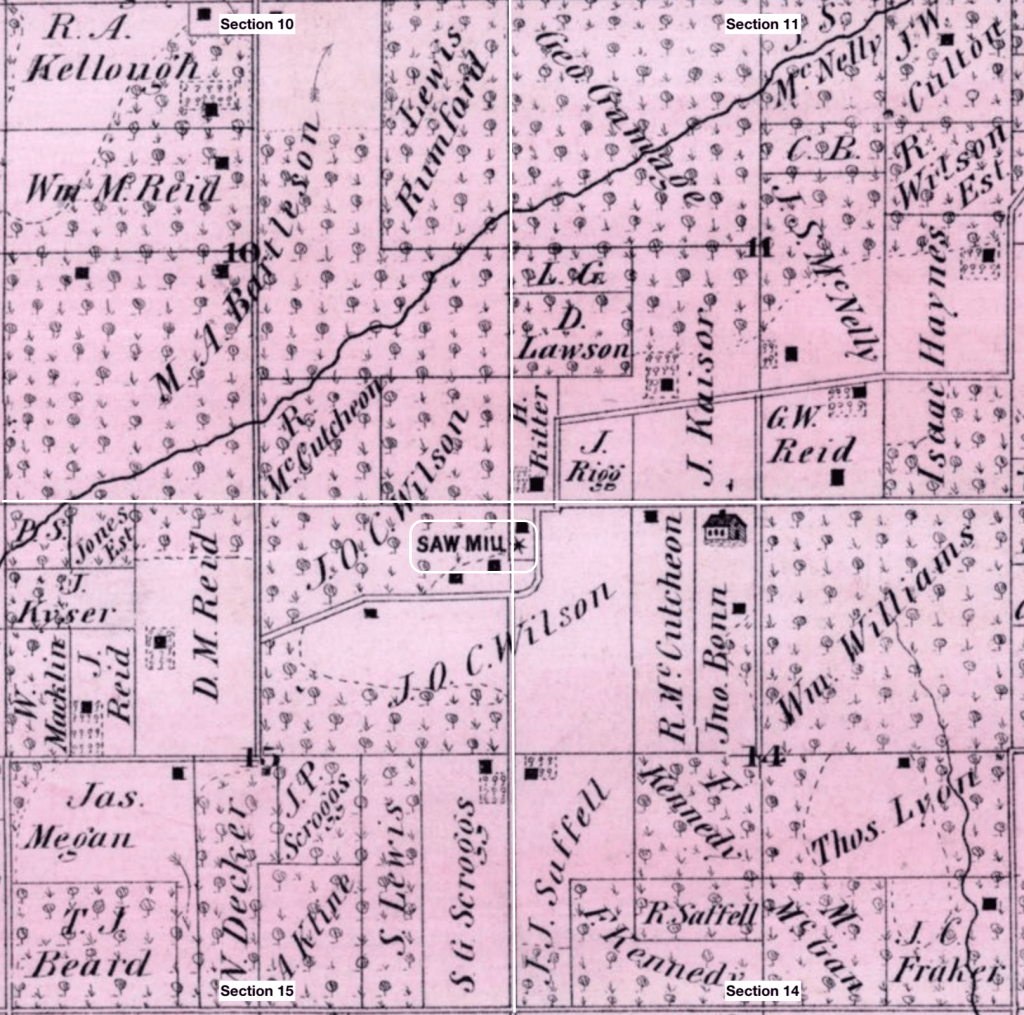
Devine Anderson is recorded in the History of McDonough County, Illinois on page 818 as having built a saw mill with J. O. C. Wilson on section 14 of Chalmers Township in 1840. The mill is marked on the 1871 Atlas of McDonough County. The excerpt shows sections 10, 11, 14, and 15 of Chalmers Township and in the center is the sawmill on land owned by J. O. C. Wilson.
The History of McDonough County noted that it was operated until 1856 when it was destroyed by fire, and a new saw mill was erected and operated by other partnerships with Wilson.
J. O. C. Wilson was a prominent politician and merchant in McDonough County, Illinois and his biography is written up in the History of McDonough County on page 376. The biography consists of the following lines:
“In 1833 [Wilson] came to this county and bought a farm near Macomb, and engaged in farming. The purchase consisted mostly of unimproved land, having on it a small cabin. With characteristics energy he went to work to improve this place, and there lived 18 months. He then rented for a time and then afterward sold it, the purchaser, among other improvements erected a saw mill, but was unable to make the necessary payments on the land, and it reverted to Mr. Wilson.“
The unnamed purchaser could reference the Anderson family. Devine, based on census and burial records, was born about 1823, making him ten years old when Wilson purchased the land, and 15 when the unnamed purchaser likely entered into the mortgage around 1835. In 1840, when Devine is said to have built the mill, he would have been around 18 years old. He may have been the son of the purchaser.
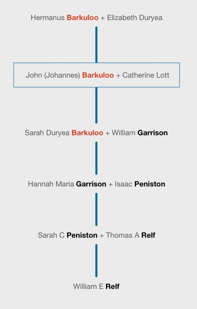
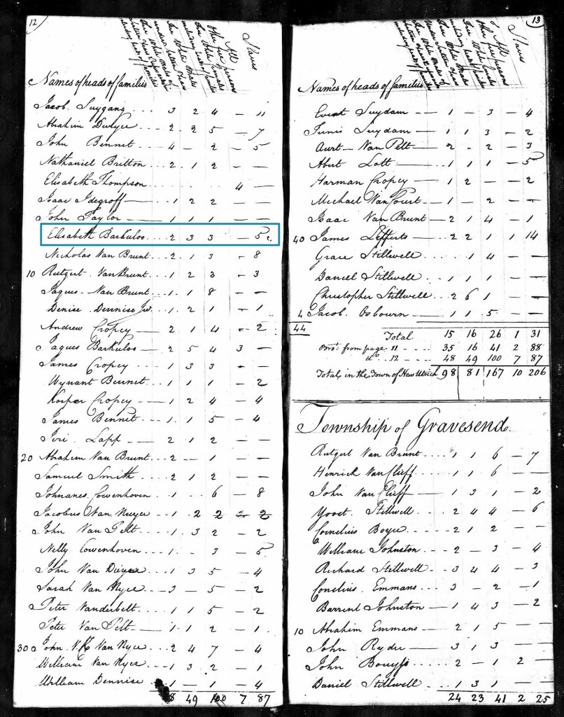
1n 1799, John Barkuloo married Catherine Lott in Jamaica, Long Island and the newspaper reported that they were both of the Narrows.
In 1800, John “Barkulow” is listed in the census for New Utrecht, Kings County, New York with a household of four members:
1 adult male 16-26 (inferred to be John)
1 adult female 16-26 (inferred to be Catherine)
1 female under 10
1 other free person excepting Indians
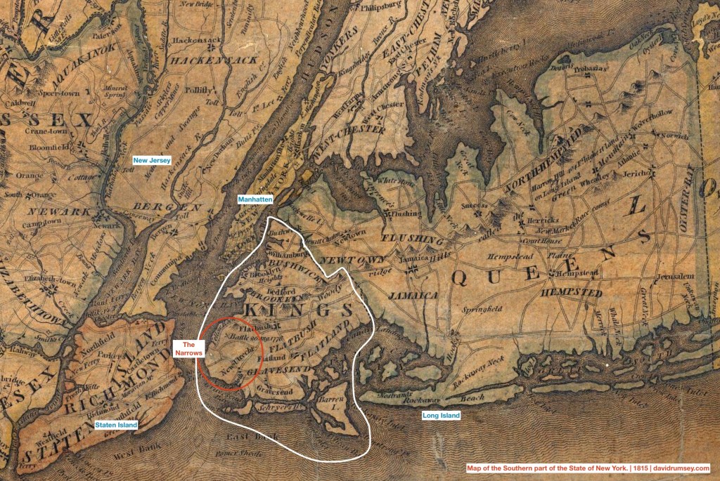
The Narrows
The Narrows is a strait of water between Staten Island and Long Island. As it provides access to the New York Bay and the Hudson River, it is the maritime “gateway” to New York.
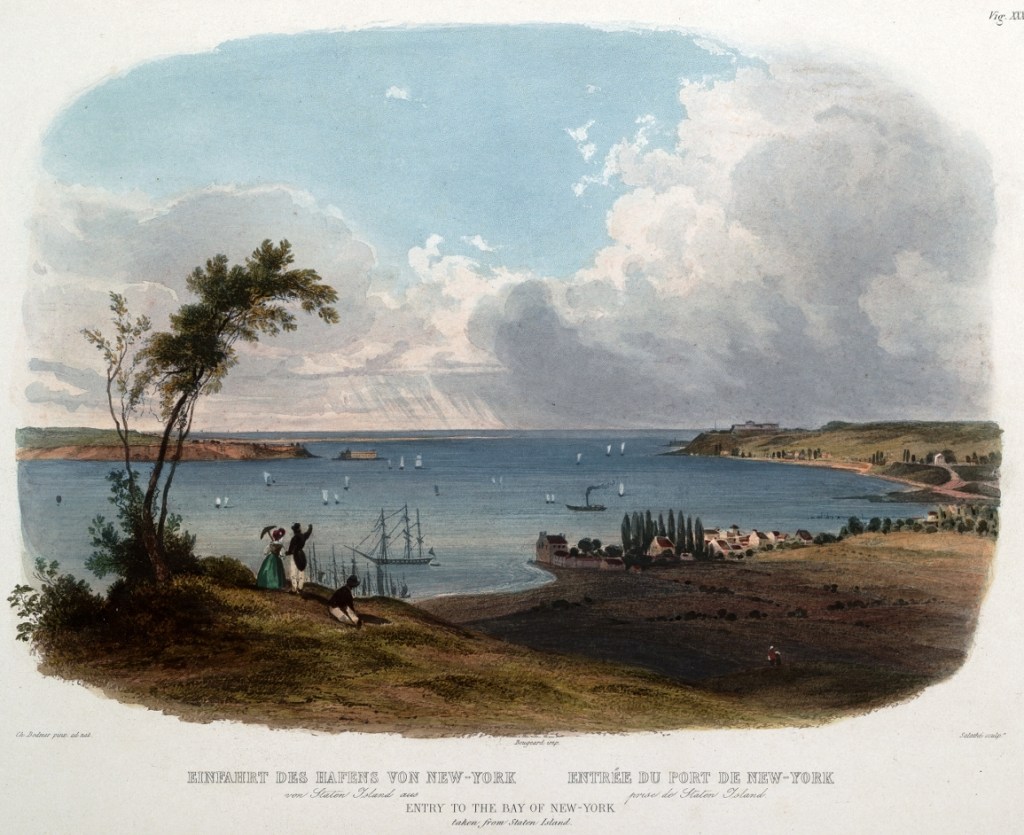
Karl Bodner | 1832-1834 | Entry to the Bay of New York (from Staten Island)
The Barkuloo family had lived in New Utrecht, at the Narrows, since their arrival in the 1600s. John Barkuloo’s great-grandfather, William Hermanse Barkuloo married the daughter of Jacques Cortelyou, a surveyor. Cortelyou, on behalf of the Dutch West India Company and the officials of the Dutch colony, surveyed the land that they had “purchased” from the Canarsie Indians. New Utrecht was one of five towns established by the Dutch when they expanded their settlement from Manhattan into Long Island.
In 1706, William Barkuloo was assessed as owning 90 acres of “improvable lands and meadows” in New Utrecht. In 1707, William Barkuloo with his wife Maria, received more land from Jaques Cortelyou and his wife, Aelkie, “bounded south by Helena Tunisse, widow, North by Lawrence Jones, West by Saltwater River and East by Common Woods.” (Vol. I. Kings County land records. Index, Ancestry.com. Historical miscellany | Image 311, record 306). The Barkuloos received lad on land near the Nayack Indians, near where Fort Hamilton would be built in the early 1800s and where the eastern tower of the Verrazzano-Narrows Bridge would be built in the mid-1900s.
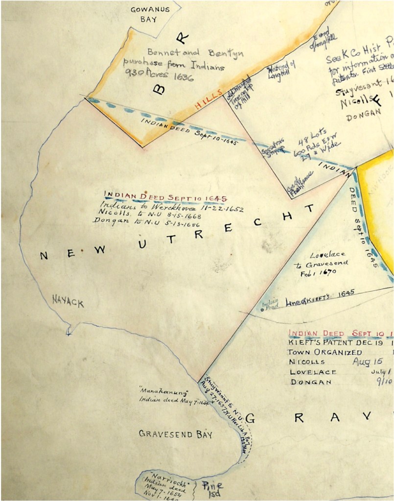
Patents of Gravesend, Flatlands, Flatbush, New Utrecht, and Parts of Queens, Newton, Flushing, Jamaica, Unknown publisher and date; Brooklyn College Library Archives and Special Collections.
In 1804, Jeremiah Lott surveyed the land of the “Nyack Patent” and identified the parcels of land that were owned by Euro-Americans: among them the heirs of the Hermanus Barkeloo. The map shows three parcels of land north of Nyack point along the shores of the Narrows and across from Staten Island.
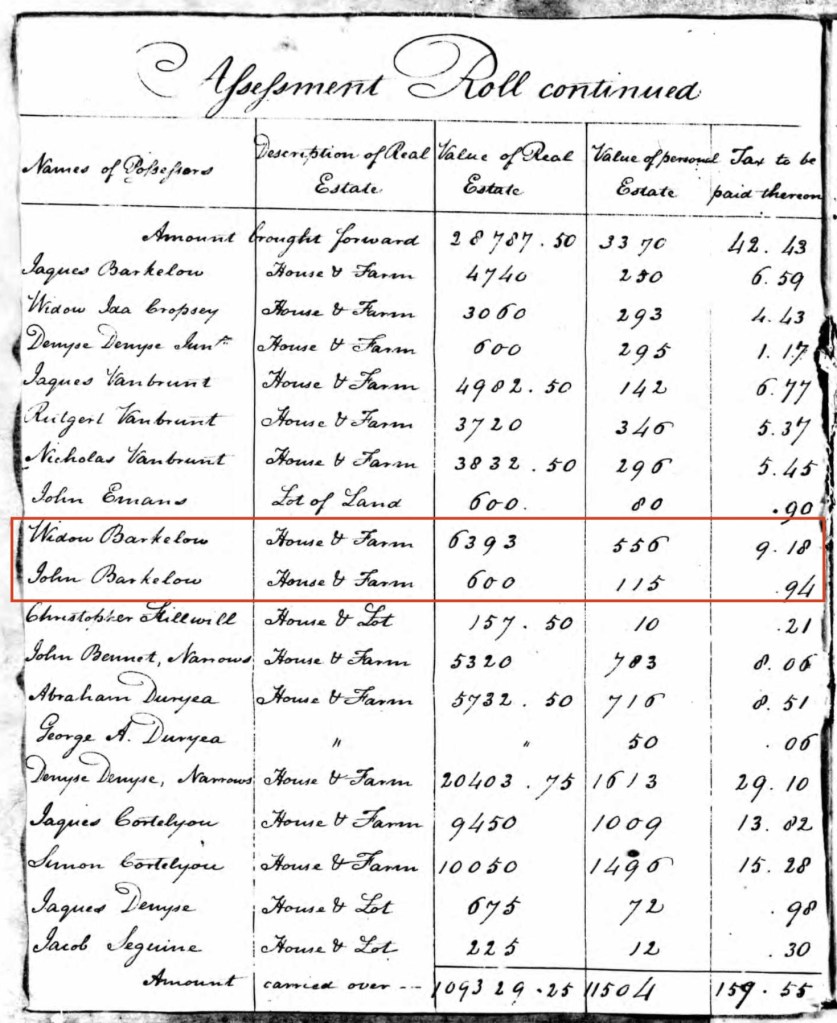
The Widow Barkeloo appears in the Tax Assessment Rolls of Real and Personal Estates, 1799-1801 for King’s County as holding land with a house and farm valued at 6,393 (the currency is not indicated). In 1801, listed immediately after the Widow, is John Barkeloo with land including a house and farm valued at 600.
Ancestry.com. New York, U.S., Tax Assessment Rolls of Real and Personal Estates, 1799-1804 [database on-line]. Provo, UT, USA: Ancestry.com Operations, Inc., 2014. | Image 3
Agricultural Labor of New Utrecht
The Euro-Americans of Long Island were heavily engaged in the production of agricultural products, including wheat and enslaved the largest population of Black people in the northern colonies. The five towns established by the Dutch West India Company on Long Island were surrounded by large farms and Long Island remained rural into the mid-1800s. The Dutch West India Company brought many enslaved Africans to New York to build the colony and labor in maritime and agricultural economic centers. Cortelyou, as a surveyor for the Company, had used enslaved laborers while engaging in company work. The 1755 Census of slaves for Lower New York lists a “Sarrtje Barkeloo” who enslaved two people one male and one female, in the township of Newuytreght [New Utrecht].
Many of the Euro-American colonists enslaved Black people to work the land, including Elizabeth Barkuloo, the mother of John Barkuloo. The 1790 Census indicated her captivity of 5 people who she mostly likely used to farm her extensive holdings. The 1800 Census shows she increased the number of people she enslaved to 16. John Barkuloo’s record does not indicate slaves, though he has an individual categorized as “all other except Indians” in his household which suggests that he may have used the labor of a free Black person in his household.
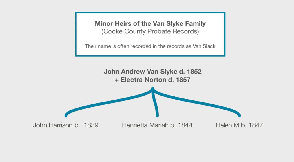
In 1852, Henrietta’s father, Andrew Van Slyke died. In 1857, her mother. Her eldest sister and her husband moved back to Texas to administer the estate and three siblings were sent to lived with three separate guardians. Guardianship was a legal arrangement to manage the property of those considered unable to manage it themselves, either due to mental capacity or age. In the case of the Van Slyke minor heirs, they were minors, and their parents left them around 1,000 acres of land in Cooke County, Texas, along with their three married sisters.
The three men assigned as guardians to the heirs had property. Daniel Montague, Henrietta’s guardian, had real estate valued at $2000 and a personal estate valued at $3845 in the 1860 census. He enslaved a Black woman, age 45. Henrietta’s sister, Helen had been assigned Allan J Mann as her guardian, and by 1860 was living in the household of J A McGarity. In the 1860 tax rolls, Mann is listed as Helen’s guardian and he had acquired 110 acres in addition to his original patent on Davies Creek northwest of Gainesville. His real estate was valued at $2500 and real estate valued at $3250. Mann enslaved a Black woman. John Harrison, their brother, had been assigned Thomas Rutledge, an emigrant from Ohio whose land was valued at $1000 and personal estate at $1455 in the 1860 census.
Daniel Montague, Guardian
In the 1860 US Federal Census, Henrietta is living with her guardian, Daniel Montague in Gainesville, Texas (Cooke County). Montague was an early settler colonizer in the Red River area of Texas, arriving in 1837 with his family after having established a plantation in Louisiana. Trained as a surveyor, he was instrumental in the Euro-American settlements and counties along the Red River. In 1854, he was elected district surveyor; in 1858 & 1862, County Commissioner and in 1863, State Senator. Montague County, the county immediately west of Cooke County was named for him.
1860 Map of Texas by Samuel Mitchell | davidrumsey.com
Many of the northern counties in Texas, including Cooke County, opposed secession in 1861. Nonetheless, the men holding political offices, like Montague, were slaveholders and used their economic and political power to ensure support for the Confederacy. In 1862, Daniel Montague was one of the chief participants the “Great Hanging of Gainesville”. When the major slave-holders in Cooke County including a Confederate officer, learned about a “Union League”, they established an extrajudicial “Citizens Court” to determine the guilt of the suspected Unionists. Montague was elected to act as jury foreman. Six other men on the jury were also slave holders in a county where 11% of the household enslaved people.
The Confederate officer who helped to organized the “Citizens Court”, James Bourland, had long written his officers about the number of deserters and jayhawkers in the region and had expressed contempt for the men who had joined the Frontier Regiment as avoiding service in the Confederate Army. Bourland had his troops arrest over 150 men for desertion. Bourland and another confederate office, William Young, whom Bourland put in charge of the court, enslaved 25% of the Black people in Cooke County. Young had led the “Red River Volunteers” with Bourland and Montague in the Mexican War in the 1840s.
The kangaroo court executed 41 suspected Unionists. At first, they executed one to two men at a time after their trial. However, the mob that formed demanded a more urgent execution of the men and the court handed over 14 men to be lynched without a trial. 19 men who had been found not guilty by the court, were returned to the court and this time, without new evidence, retried for the same crime, found guilty and executed, again because of the demands of the mob.
Montague and his family left Cooke County after the Civil War, moving to Mexico.
Henrietta Mariah lived in Montague’s household during the 1860 census and did not marry until 1865, suggesting that she lived in his household while he commanded the lynch mob. How Henrietta was included into the household is unclear; was she expected to perform household labor in exchange for room and board, or was she considered like a family member with similar chores to the other daughters.
Marriage to Thomas B Jackson
In 1865, Henrietta married Thomas B Jackson, a Confederate veteran living in Grayson County. He had enlisted in the 11th Calvary (Confederate) near the beginning of the war in October 1861 at Camp Reeves. It was led by William Young, the same Confederate Official who had organized the “Citizen Court” of the Great Hanging. The regiment engaged the Chustenhalah nation in battle in the Indian territory and fought at the Battle of Pea Ridge in Arkansas (March 1862).
The regiment was sent to Tennessee and Kentucky to fight. In Dec 1862, the regiment fought at the Battle of Murfreesboro. The next fall and winter, the regiment was stationed near Knoxville, Kentucky and two large federal raids captured multiple members of the regiment.
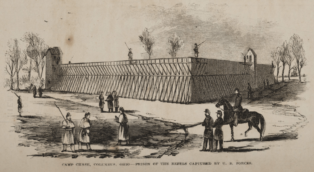
Camp Chase, Columbus, Ohio–Prison of the rebels captured by U. S. forces. | Frank Leslie’s Illustrated Newspaper
The muster records for Jackson noted that he had gone missing from the army in November 1863 near Knoxville, where the Confederate army had surrounded the Union garrison (November 19-December 4).
Cleveland Daily Leader (Cleveland, Ohio) 9 Dec 1863 | newspapers.com
He was officially marked as a deserter on 1 Dec 1863. Federal forces captured Jackson on 6 Dec 1863 and sent him to Camp Chase in Columbus, Ohio before transferring him via Louisville to Rock Island, Illinois. He was paroled from prison in June 1865 after he took an oath of allegiance to the United States.
Henrietta married Thomas B Jackson in October 1865, four months after he was paroled. She lived with her husband in Cooke County until his death in the 1895. In 1910, she was living with a younger daughter in Oklahoma and died in 1919.
Lucas, Mattie Davis & Hall, Mita Holsapple. A history of Grayson County, Texas / Mattie Davis Lucas (Mrs. W. H. Lucas) and Mita Holsapple Hall (Mrs. H. E. Hall), book, 1936;Sherman, Tex.. (https://texashistory.unt.edu/ark:/67531/metapth24648/:accessed June 27, 2022), University of North Texas Libraries, The Portal to Texas History, https://texashistory.unt.edu; .
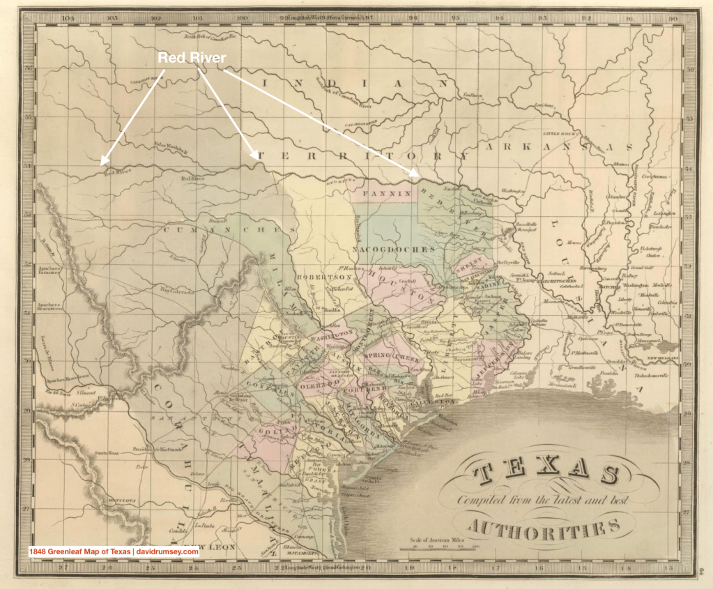
Europeans and Euro-Americans designated the Red River as boundary for a long time. The French and Spanish viewed it as dividing line in the 1700s, the US and Spain continued its use as a border in the 1819 Adams-Onís Treaty in conjunction with Mexico. The Republic of Texas used it as a boundary.
The Southern Plain Indians had been living in the land north and south of the Red River for centuries prior to the arrival of Euro-Americans. The Wichita, the Comanche, the Kiowa, the Osage were among the Indigenous people that traveled the Plains as hunters and gatherers, following the buffalo and other large game back and forth across the Red River.
Settler Colonizer
In the 1840s, Euro-American settlers began to intrude into the areas populated by the Caddo, the Kickapoo and the Comanche south of the Red River. The Van Slyke family came from Arkansas and Southwest Missouri to acquire and settle land as part of the Peters Colony.
1852 Arkansas, Texas, and Oklahoma | davidrumsey.com
In 1849, their eldest daughter, Elizabeth, married James Hamilton, an Irish immigrant, in Grayson County, Texas. In 1850, the Van Slyke family is went farther west into the newly organized Cooke County while the Hamiltons are likely living on the claim James Hamilton had in Grayson county, about 5 miles southwest from Preston. Hamilton received 320 acres as part of his headright as a single man who immigrated to the colony prior to 1848. He sold the land in 1852 for $108.
1852 is the same year Elizabeth’s father died and is likely when the Hamiltons moved back to Arkansas as evidenced by the birthplaces listed for their children in the 1860 census. The family returned to Texas when Elizabeth’s mother died in 1857, leaving her younger siblings without guardians. Her husband administered the estate.
In 1860, James Hamilton and his wife and three children, have migrated farther west into Montague County, which was named after Daniel Montague, a prominent Euro-American citizen in Cooke County who surveyed much of the land. The Hamiltons are listed in vicinity of Montague Post Office.
1860 Map of Texas by Samuel Mitchell | davidrumsey.com
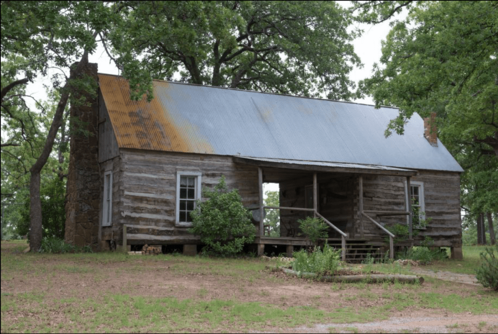
Some of the recollections of settlers often describe their homes as “dogtrot” log cabins. A double log house, the “dogtrot” cabin would have a covered breezeway between the cabins. The Brumley family who were enumerated next to the Hamiltons on the 1860 US Federal Census were said to have lived in the a dogtrot cabin.
An old “dogtrot” cabin at the Grayson County Frontier Village and Museum at Loy Park in Denison, Texas | The Lyda Hill Texas Collection of Photographs in Carol M. Highsmith’s America Project, Library of Congress, Prints and Photographs Division.
Borderlands
The land along the Red River border was contested as the Indigenous nations had been living in the region prior to the Euro-American settler colonizers arrival in the 1840s and the Indigenous nations utilized strategies to maintain access to their homeland. Prior to the Civil War, the US Army had regiments stationed in a series of “frontier forts” in an effort to remove the Wichita, Kickapoo, Comanche, Caddo and other Indigenous nations to allow for white settlers to take the land for their own.
Fort Worth (of Dallas-Fort Worth) was fort farther north of the line of forts that stretched from the Rio Grande to the Red River. As settlers continued to intrude west into territory commanded by the Indigenous nations, conflict over the lands and settlements occurred.
Civil War
US Army Withdraws Protection
When the Civil War started and Texas seceded, the US Army withdrew and the Euro-American settlers left in the new Confederate States of America no longer had the same military force to block the Indigenous peoples from returning to their territory. Ironically, Texas “listed frontier protection as a major reason for secession after the protection of slavery”, yet as the Confederate Army focused its energies on the east and the US Army, it continued to pull forces from the western borderlands.
Over the course of the Civil War, the borderland between the Euro-Americans settlers and the Indigenous nations shifted east instead of west, as it had done prior to the war. In Dec 1861, the “Frontier Regiment” was authorized by the Texas Legislature to raise a regiment of rangers to protect the northern and western borderlands to replace the withdrawn Confederate forces.
Frontier Regiment
Near Red River, on the Salt Creek was a large animal crossing, where the buffalo would cross the river, and following them the Indigenous hunters. The Indigenous nations would also use the crossing when they resisted Euro-American settler colonists by sending raids across the river to disrupt settlements on their hunting grounds. It was near here that the Texans established the Red River Station as part of their “Frontier Regiment” to guard the Euro American settlements from Indian raids.
Captain John T Rowland enlisted over a hundred men from around Montague and Cooke County for the Red River station, including James M. Hamilton who enlisted in Dec 1862. The intent was that men stationed would send out daily scouting parties between the stations to effectively patrol the borderlands. Col. McCord tried to create a more aggressive role by advocating for larger patrols to be sent beyond the borderlands into the territory controlled by the Indians in an attempt to “search and destroy” the Indian bands. The legislature commanded him to keep the role of the regiments as a defensive presence in the borderlands. The regiments were underwhelming in their ability to provide defense.
Settlers Retreat East
In early 1863, Jas. J. Diamond wrote General Steele about conditions in Gainesville (Cooke County):
We found our country invaded by the Indians, jayhawkers, &c., and our people most ready to flee their homes and sacrifice to the foe their large possessions of cattle and horses, as well as promising fields of grain….The troops on the frontier directly west, under State control, are unable to aid us in this defense. The stealing and murdering parties come into our county [Cooke County] and Montague from the north, that is out of the Indian Territory.
OR, ser 1 v22 pt 2 page 800
In 1889, John Wesley Wilbarger compiled stories of 250 “depredations” [19th century term for Indian raids], chronicling the conflict from the 1820s to the 1870s. Wilbarger wrote from the perspective of a settler colonizer who viewed intrusions into Indian territory as part of “Manifest Destiny”. In his text, he describes how the Indian raids “caused a general desertion of the organized northwestern counties. The counties, Stephens, Palo Pinto, Jack, Wise and Montague were almost entirely abandoned by the [Euro-American] settlers, only a few cowboys remaining at the large ranches — or as they were then called, “forts.”
Morale and Regard
Confederate leadership viewed the northern Frontier Regiments with suspicion, believing that many of them were deserters or only joined the regiments to escape enlistment in the Confederate Army. Col James Bourland, after touring Red River Station specifically declared the men “disloyal Texans” for their avoidance of the Confederate Army and that they were solely focused on protecting their local communities rather than the Confederate cause.
December 1863 Raid
On 21 Dec 1863, about 300 Comanches entered Montague County relatively near the Red River Station and attacked a settlement called Illinois Bend along the Red River close to the boundary between Montague and Cooke Counties. The Comanches attacked three homesteads, killed some of the settlers and burnt the homes before moving to their next target near Wallace Settlement, east along the River. They crossed back across the river, convincing the following Frontier Regiment into thinking the raid had ended and the Regiment rested near the Wallace Settlement for the evening. The next day, the Comanches crossed the river back into Texas and continued attacking settlements along the river as it got closer to Gainesville, situated in the center of Cooke County.
The Frontier Regiment was unable to defend the northern Texas border, as the Comanches outnumbered the men in the regiment and were able to disperse quickly when the regiment gained proximity to the group. Horses were stolen, ten homes burned, and twelve were killed in the raid with seven wounded.
In the year that followed there were few attacks by Indians on the Euro-American settlers, and an author wrote “perhaps the reason was that the country was so full of jayhawkers [Union guerrilla fighters], deserters, renegades and military parties hunting them, that the Indian considered it a very unsafe place.”
By March 1864, as the war entered its third year, the Confederate Army needed men farther east and south, and reassigned those in the Frontier Regiment into the Confederate State Army. No longer under command of Texas for the purpose of defending their settlements, the men were drafted into larger army to battle the Union Army over the political goal to maintain chattel slavery.
An April 1864 Letter from James Bourland to Brig. Gen McCullough reported that two-thirds of the force at Buffalo Station and Fork Belknap had deserted and “We do not know if any have left Salt Creek Station [Red River Station] or not. Captain Roland is here.”
James Hamilton appeared on the muster roll of the newly created regiment for the CSA in April 1864, and then his records end. The Hamilton family have yet to be located in the 1870 census.
Ely, G. S. (2007). Gone from Texas and Trading with the Enemy: New Perspectives on Civil War West Texas. The Southwestern Historical Quarterly, 110(4), 438–463. http://www.jstor.org/stable/30239529
United States. War Records Office, et al.. The War of the Rebellion: a Compilation of the Official Records of the Union And Confederate Armies. Washington: Govt. Print. Off, 18801901. [OR]
Wilbarger, J. W. (1985). Indian Depredations in Texas. United States: Eakin Press.
Southwestern Missouri during the Civil War was burned to the ground by guerrilla warfare. Many civilians left Jasper County after the war due to the intensity of the violence and destruction wrecked by the irregular warfare. When the war was over, “There was not much to return to”, writes Schrantz in his history of the Civil War in Jasper County.
All the towns and villages in the central and western part of the county were in ashes and those the easter part were either destroyed or badly damaged. Most of the farm houses had disappeared and all over the region were skeleton chimneys, surrounded by fallow, weed grown fields. In the main the district had reverted to the wilds. Deer , wild turkey and game of all sort had increased tremendously during the last years of the war and early comers after the struggle state that wolves were so tame that they could be shot from the wagon seat of those who at wide intervals drove along the seldom used roads.
Schrantz, p 240
Schrantz claims that many of those “who had fought for the cause of the south, particularly those who had taken part in the partisan warfare that had been so bitter in this region, did not return.” Instead, immigrants from Kansas and “former federal soldiers who had seen this country during the military operations and liked it” came instead.
Three households living in the vicinity of Carthage, Missouri enumerated together in the 1870 census demonstrate the sentiment in this statement.
Early in the war, Malissa Ann Rickner lived with her first husband, W. K. Franklin on the town square in Carthage and was most likely present for the Battle of Carthage. Franklin died early in the war, and in 1866, she remarried a Union Veteran, Archibald Danford. She was married by her cousin, James Rickner who was the Justice of the Peace.
Archibald Danford had served in the 13th Wisconsin Infantry. In 1862, the infantry was stationed at Kansas forts, marching to Fort Scott, then Lawrence, Kansas, and then to Fort Riley and Fort Leavenworth. It was later sent to other parts of the war.
In the 1870 Census, he is living with Malissa and their children, as well as his brother-in-laws: William and Jeptha.
Household 2: James Rickner
ancestry.com
James Rickner, the eldest son of Jacob Rickner, was a native to Jasper County. His biography n the History of Jasper county states that he was a “staunch Union man” and he served in Company B of the 9th Regiment Missouri State Militia. The biography states obliquely “His service was of a nature familiar to all old settlers of the Southwest”. The primary purpose of the Missouri State Military was to conduct offensive operations against guerrillas and oppose Confederate raids.
Missouri History Museum
Household 3: Israel & “Amelia” Ogden
Permelia Rickner was fourteen years old in 1860 and was living in McGhee County in the Kansas Territory with her father and stepmother Margaret Reneau. In 1861, her father died and it appears that her stepmother died prior to 1870. It is unclear where Permelia spent the war.
However, in 1867 she married Israel T Ogden. Unlike her sister, who had been married by the Justice of the Peace, they were married by J. C. Willoughby “Minister of the Gospel”. The History of Jasper County states that he was the first clergyman of Lincoln Township, established after the war and in honor of Abraham Lincoln, the president of the Union. He was a Methodist Episcopal pastor in charge of the circuit in Jasper County after the war, reorganizing churches and regrowing church membership.
Permelia’s husband, Israel Ogden, had served in the 17th Kansas Regiment in 1864. He and his family had lived in Linn County, Kansas, having migrated there from Illinois. Their eldest son was named Thaddeus Steven Ogden, presumably after Thaddeus Stevens, the leader of the Radical Republican faction in the Republican Party. By 1875, he had died and Permelia Jane Rickner married her second husband, John Harrison Vanslyke.
Sources:
Schrantz, W. L. (1923). Jasper County, Missouri, in the Civil War. United States: Carthage Press.
The History of Jasper County, Missouri: Including a Condensed History of the State, a Complete History of Carthage and Joplin, Other Towns and Townships …. (1883). United States: The Printery.
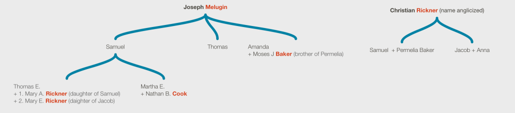
Nathan B Cook was the second son of Permelia (Baker) Cook Rickner. Permelia had married James H Cook (I) in Washington County, Missouri in 1828. In the 1830 US Federal Census, they were enumerated in Crawford County, Missouri, a neighboring county in Meramec Township, created in 1829 from Gasconade county.
Nathan’s father died prior to 1832, when Permelia remarried a Swiss immigrant, Samuel Rickner. In the 1840s, they moved southwest to what became Jasper County, Missouri.
In the 1850 US Federal Census, Nathan and his brother James are enumerated living with the Rickners east of Carthage, Missouri.
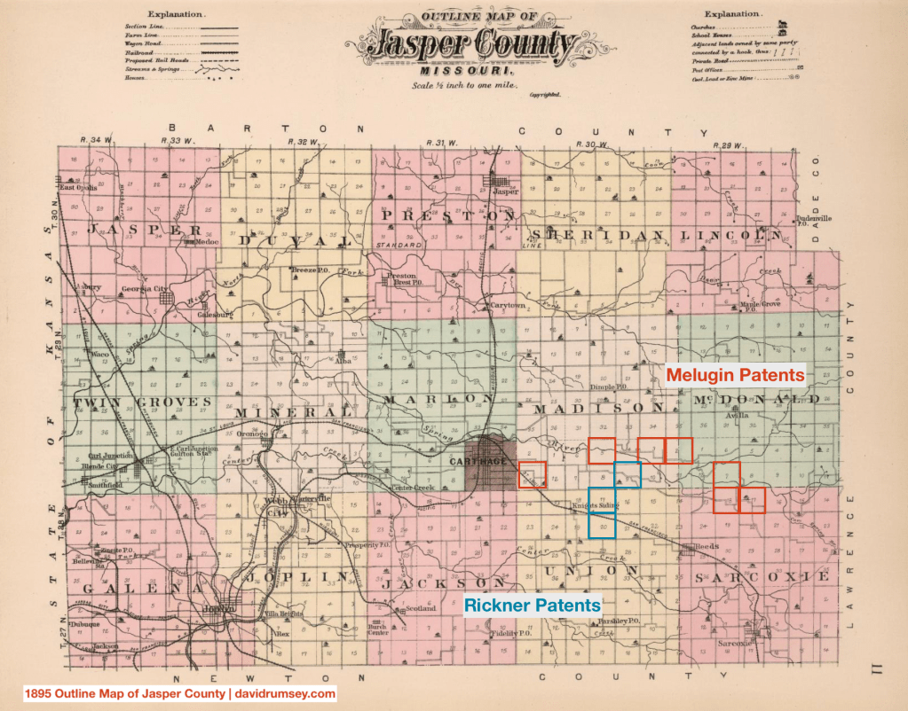
In 1851, Nathan B Cook married Martha E. Melugin, the daughter Samuel Melugin, a landowner near the Rickners in Jasper County.
The extended Rickner family had at least four marriages with the Melugin family.
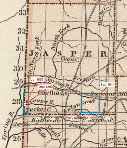
In 1858, Nathan was appointed postmaster of Valley Forge, a short lived town at the confluence of Spring River and the White Fork of Spring River east of Carthage. The post and post office was discontinued in 1859.
In 1860, before the outbreak of the Civil War, Nathan B Cook was living with his wife, Martha, and their three children on a farm valued at $1600. Samuel Rickner, Nathan’s half brother, was living with them working as a farm laborer. Christopher Rickner, an older brother of Samuel, and Jacob Rickner, the Rickner’s uncle, was enumerated on the previous page in the census, suggesting that they were close by as well.
Engagement in War
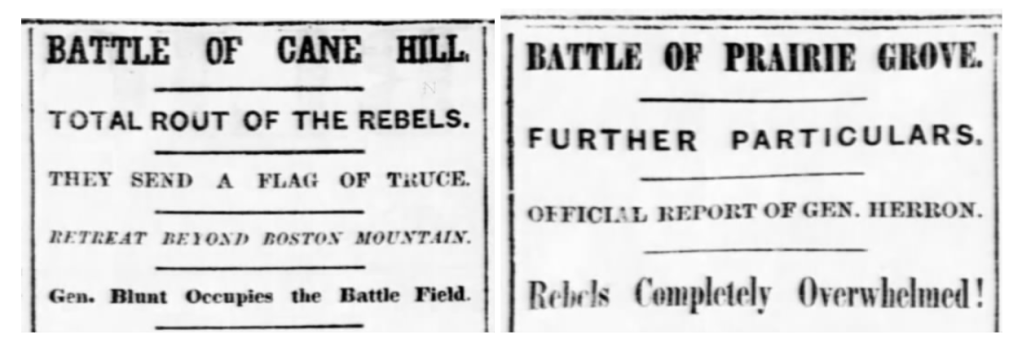
In 1862, DeWitt C Hunter, a committed secessionist began to recruit soldiers from the Missouri State Guard. Recruiting in both the border counties Missouri and the northwestern counties of Arkansas, he was able to create a regiment originally called Hunter’s 2nd Missouri Regiment. On August 23, 1862, Nathan B. Cook enlisted into Hunter’s regiment.
Headlines from the Daily Missouri Republican (St. Louis) 01 & 11 Dec 1862
In the late fall and early winter of 1862, Cook with his regiment fought at the Battle of Cane Hill and the Battle of Prairie Grove, as the Confederate Army tried to regain entry into Missouri and take control of the border state. The Confederates lost both battles, and the regiment fell back to Van Buren, Arkansas. After participating in two overwhelming defeats, the morale must have been fairly low.
Cook’s service records indicate that he may have been captured and taken to Fort Scott. The March and April 1863 Muster Roll provided the following remarks “Prisoner at Ft. Scott when last heard from”. By May 5th, he was listed as a deserter.
Capture and Imprisonment
On 10 Sept 1863, Nathan B Cook was captured near Carthage, Missouri by the Union Army. His prisoner of war records note that he “gave himself up”.
1864 Drawing of Gratiot Military Prison | wikimedia.com
Cook was sent first to St. Louis as a prisoner of war, where he expressed willingness to take the oath of allegiance to the US. He was held in the Gratiot Street Military Prison in October 1863. The Gratiot Military Prison was the largest in Missouri and used as a transfer point to other prisons.
From St. Louis, Cook was transferred to Camp Morton, Indiana in November 1863. The Camp was built on the Indiana State Fairgrounds in Indianapolis and was originally used as a training ground before it transformed into a military prison. An article in the Brookville Republican (Brookville, PA) reported that in January 1864 the prison held between three and four thousand prisoners. During the war, 17,000 prisoners died while at Camp Morton.
Cutter, E. P. , Former Owner. Rebel prisoners, Camp Morton, Indianapolis . United States Indiana Camp Morton Indianapolis, None. [Between 1862 and 1865] Photograph. https://www.loc.gov/item/2012647767/.
In May, 1864, Nathan B Cook was admitted to the General Hospital at Camp Morton for chronic diarrhea and erysipelas. Erysipelas is a skin rash usually caused by staph bacteria. The skin would become swollen and discolored. During the civil war, microbiology had not yet been established and medical doctors were unable to effectively treat the disease, unaware of how the bacteria traveled from patient to patient. Statistics suggests that about 41% of the soldiers who contracted erysipelas during the war died from it. Nathan B Cook was one of the soldiers.
He was buried in Green Lawn Cemetery in Indianapolis.
Sarah Jane Rickner, a daughter of Samuel and Permelia Jane Rickner, was born in Jasper County, Missouri in 1844. Her father had a farm east of Carthage for the better part of the 1850s. Her mother died in the 1850s and her father remarried. Samuel with his new wife set up a homestead in McGhee County, Kansas Territory. Sarah stayed in Jasper County.
1860 Household
In the 1860 US Federal Census, Sarah is enumerated in the household of W. K. Franklin, her brother-in-law. William K. Franklin had married Malissa Ann five years earlier in 1855. He was a saddler living in the town of Carthage. His real estate was valued at $1250. In addition to the Franklin family and their sister-in-law, Sarah, the household also had what appears to be William’s brother: J. C. Franklin, also a saddler. Additionally, there were four other males who appear unrelated: William Vermillion, saddler, Mathias Buss, a brickmaker, and John Snyder, a day laborer, and Shelton Sheppard. Buss had his own real estate valued at $2800.
The History of Jasper County locates the shop in Carthage:
The following description of the public square at that time, furnished by Judge John Hornback, an old citizen of the county, and a frequent visitor to Carthage, will no doubt be interesting to the reader of this work: Commencing on the northeast corner of the square, on lot number on was the residence occupied by Mr. Johnson. The first business house on the east side was on lot number two, it was a drugstore owned by Ben C Johnson; the next was a small saddlery shop, on lot number three, kept by Franklin & Vermillion, then came the Franklin House on lot number four.
A Walter K Franklin (1832-1860) is memorialized in Pioneer Cemetery; no other Franklins were listed in the 1860 census suggesting that W(illiam). K. Franklin and Walter K. Franklin are the same. After the Civil War, Malissa married Archibald Danford, a veteran of the Union Army (Wisconsin Calvary) and had likely served at Fort Scott and Fort Leavenworth in 1862.
Battle of Carthage
Missouri was a border state during the Civil War — it was a slave-holding state with many of its citizens advocating for secession. In the decade prior, “border ruffians” and “jayhawkers” had criss-crossed across the border of Missouri and Kansas in the fight to make Kansas a slave-holding state as well. In April 1861, the governor of Missouri was pro-Confederate and had refused to send troops when Lincoln requested troops after the Confederacy fired on Fort Sumter. When he instead called the Missouri State Militia with an apparent intention to seize the St. Louis Arsenal, the US responded by mustering Union forces to protect and transfer the arsenal out of pro-Confederate control. In June 1861, the Federal troops tried to capture Jefferson City (then state capital) and the governor and his militia retreated to Boonville, Missouri. The Federal troops followed, forcing the further retreat to Springfield and then Carthage, Missouri.
The Battle of Carthage in Missouri, in 1861 during the American Civil War. Illustration from Civil War Harper’s Weekly. | wikipedia
The Battle of Carthage was fought in July 1861. The battle started 10 miles north of Carthage and steadily moved south into the town and the town square, where the Franklin & Vermillion saddlery shop was located and where the Franklin family lived with Sarah Rickner. The two sides “engaged in a firefight around the original brick courthouse and the wood-framed buildings that made up the square at the time.” (Joplin Globe, 23 June 2022). The Confederate forces forced the retreat of the Federal troops.
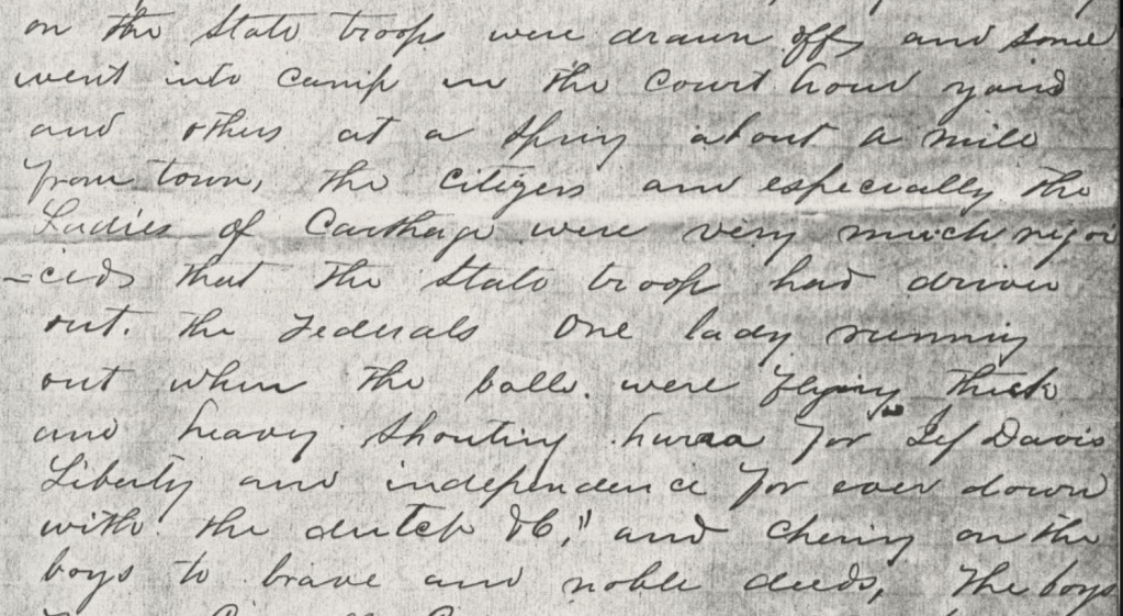
An Archy Thomas wrote a short six page memoir of the Battle of Carthage (n.d.). In his memoir he described at the end of the battle how “the state troops … went into camp in the court hours yaird [sic] and others at a spring about a mile from town, the citizens and especially the Ladies of Carthage were very much rejoiced that the state troops had driven out the Federals One lady running out when the balls were flying thick and heavy shouting hurra for Jef [sic] Davis Liberty and independence forever down with the dutch &c. and cheering on the boys to brave and noble deeds”
page 4 of the Archy Thomas Memoir | Missouri Digital Heritage
A battle report printed in the Baltimore Sun (Baltimore, Maryland, 12 July 1861) describes how “the loss of Jackson’s side [Confederate] was very great. Our informant says he counted between seventy and eighty wounded on the field and in houses by the wayside. At Dry Fork, a large amount of beef was thrown out of the wagons, it is supposed to make room for the dead. Another informant, a resident of Carthage, states that he passed her a part of the battlefield yesterday morning and saw wagons and hacks passing in every direction, gathering up the dead for interment.”
Carthage During the War
Jasper County Court House 1849-1863 | Schrantz, Jasper County. Missouri, During the Civil War
In the fall and winter after the Battle of Carthage, the Confederates had control of southwest Missouri. Residents who supported the Union were “encouraged” to leave and many went to either Fort Scott or Springfield. As they withdrew in 1862 and 1863, they took pains to “prevent Carthage from becoming a place of shelter for the Federal forces.” The town was ruined and “nearly every building” was destroyed. Carthage became a “heap of ruins”. Union forces “made a fort out of the ruins of the courthouse, in the public square, but it was afterward destroyed by rebels.” A band of guerrillas, thought to be associated with Bill Anderson, burned the courthouse in 1863. The History of Jasper County recounts only three or four buildings left standing in Carthage at the end of the war.
Where Sarah Rickner and the widow Malissa Franklin lived during the ruin of Carthage is unknown. Sarah’s obituary in 1945 states simply “Her family was among many of the early settlers who lost all they had due to the turmoil of a civil war.”
Stolen Horse
At some point, date unknown, Sarah’s horse was taken by the Union soldiers.
Mrs. Gaither [Sarah Rickner] was a young woman during the civil war and often recalled many incidents of that time. She was an expert rider and her father gave her a horse of racing blood.
Obituary | Joplin Globe, 9 Aug 1945
The 1860 Agricultural Schedule of the US Federal Census recorded information about Samuel Rickner, Sarah’s father, homestead in McGhee Kansas, where he had 9 horses on his 160 acres of land in addition to 30 pigs and 30 sheep. Her uncle, Moses J Baker, was said to raise mules, suggesting that both sides of the family engaged in horseflesh.
One day, when she was away from home, some union soldiers took her horse and left a worn-out nag in the lot. When she discovered the exchange, she went immediately to the union officers, and demanded her horse, which was returned to her.
Obituary | Joplin Globe, 9 Aug 1945
After the War
Sarah married a Confederate veteran named Edward Thomas Gaither who was described as a Carthage mercantile businessman and farmer. She married him on April 8, 1866. in 1882, he opened a grocery, provision, and feed store in Carthage.
Sources:
Schrantz, W. L. (1923). Jasper County, Missouri, in the Civil War. United States: Carthage Press.
The History of Jasper County, Missouri, Including a Condensed History of the State, a Complete History of Carthage and Joplin, Other Towns and Townships. (1883). United States: Mills & Company.
Samuel Rickner married Permelia Baker in 1832. Rickner, an immigrant from Switzerland, married into a slave-holdinng family that had migrated to Missouri from Kentucky and who in previous generations had migrated from the Albemarle Sound region of North Carolina, all slave-holding states.
In the mid 1830s, the Rickner family and Permelia’s brother, Moses J Baker migrated again, leaving Washington County, Missouri for southwestern Missouri. The land was still predominately occupied by American Indians who had been removed from their homelands in the east. In 1837, rumors spread the the Osage “were coming” and the Missouri government sent a sizable militia to the area. The Osage, out-numbered, surrendered. By 1840, the land would be organized into counties, that were rapidly subdivided into smaller counties as the Euro-American population grew and the American Indian population was killed or removed into the Indian Territories (Kansas & Oklahoma).
Moses J Baker
Moses J Baker, Permelia’s brother, married Amanda Melugin in Barry County in 1838. Three Melugin families were living in Marin Township, Newton County (immediately south of Jasper County) in the 1840 census. Joseph appears to the patriarch with his two sons: Samuel and Thomas. Land patents given by the US Government in the 1840s and 1850s specify acreage in Jasper County and in the 1850 Census, the Melugins are living near Sarcoxie, Jasper County, Missouri. Sarcoxie is named as one of the earliest Euro-American settlements in Jasper County and is said to be named after an Osage chief. The Melugins had migrated to southwestern Missouri from Tennessee. Many of the Euro-American settlers had come from Kentucky and Tennessee like the Bakers and Melugins.
In 1857, Mary Ann Rickner, daughter of Samuel and Permelia Rickner married Thomas E. Melugin, son of Samuel Melugin and they lived on a farm in McDonald Township. Amanda Melugin, wife of Moses Baker, died prior to 1850.
Moses remarried after the death of his wife Amanda, to Nancy Jackson. Baker who had acquired land near the Rickner’s and Melugin’s in the 1840s, acquired land on the western border of the county, near the border of Kansas Territory in the 1850s and 1860s.
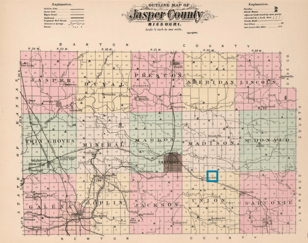
In 1850, Baker’s land was valued at $1000 and and in 1860, his land was valued at $3500. Additionally, he enslaved two children, Martha, age 13, and Ella, age 5. He was living within the vicinity of the town Sherwood, a town settled by Andrew McKee, who enslaved multiple people and ran a trading post with agents in the Indian Territory. Located near Center Creek, flatboats would run goods to the Arkansas River via Spring River. The town had about 200 inhabitants, stores and a brick school house when the Civil War began in 1860.
Bleeding Kansas
Mural entitled Tragic Prelude depicting the abolitionist John Brown standing between the two sides.
Prior to the Civil war, there had been violence along the border of Kansas and Missouri as a result of the Kansas-Nebraska Act of 1854. The decision to allow popular sovereignty to decide if Kansas would be a “free state” or not created conflict between the groups on either side of the slavery “question”. The conflict was not only marked by electoral fraud, the establishment of two capitals, but also raids, assaults and murder.
In McGee County, Kansas, where the Rickners homesteaded prior to the Civil War and across the border from Moses Baker’s land, the electoral fraud was flagrant: the ballot returns for an 1857 election showed that 24 settlers voted the free-state party, while 1,202 votes for a Democratic (pro-slavery) party. The 1860 census only enumerated 815 males with 429 of them less than twenty years old, which made the electoral fraud obvious.
The political conflict soon became gang violence as groups used the question of slavery to justify their acts of violence. The pro-slavery gangs from Missouri were called “border ruffians” and the anti-slavery gangs from Kansas were called “jayhawkers”.
Jayhawker Attack
Antislavery guerrillas under Charles Jennison attacking civilians in Missouri. | loc.gov
An unnamed source claims that “jawhawker bands swooped down on the Baker farm and drove off a herd of 700 mules” early in the war. It is possible, as raids were conducted by both sides. In fact, in August 1861, George W. Broome, a wealthy landowner and slave holder from Georgia who lived in the township/range north of Baker had his home attacked, mules stolen and his life taken by “a band of marauders”. The attackers were said to have stolen forty horses and ponies. In March 1861, Broome advertised the sale of hundreds of acres of land in Jasper County and that he would take Black people as payment for the sale.
Broome’s real estate was valued at $25,000 in the 1860 census. The red box shows the area where he owned his lands.
Three sons from the Ireland family were accused of participating in the raid on Broome’s life and goods. Abraham Ireland, the father of the three sons, was a neighbor of Broome’s, enumerated immediately before him in the 1860 census. Unlike his neighbors, who migrated from Tennessee, Kentucky and other southern states, Abraham Ireland was from Ohio and his sons born in Indiana.
Unnamed prominent citizens found one of the sons and held an extrajudicial trial for the son and lynched him. The other two sons were also murdered. From where they died, it appears they were tracked down. One was killed at a trading post on Spring River, and the other on Lightening Creek in Kansas.
While the family anecdote claims that it was a raid on Baker’s farm that inspired his next steps of joining the border ruffians and getting revenge on the jayhawkers, it may very well have been the raid on Broome’s home.
While most retellings of the events claim the deaths were caused by unnamed prominent citizens, rumors swirled that Baker had a hand in the trial and death of the lynched Ireland son.
On 27 November 1862, the Leavenworth Times announced that “Capt. Coleman … captured Capt. Baker of Livingston’s command, directly after the raid on Dry Wood, and the said Capt. Baker being a very noted character on Shoal Creek and Spring River, and was at the hanging of Ireland and is accused of putting the rope around Ireland’s neck.”
Two unidentified Border Ruffians with Swords | loc.gov Photograph shows pro-slavery activists from Missouri who crossed into Kansas Territory between 1854 and 1860 to promote slavery.
Border Ruffian and Bushwhacker
In 1883 The History of Jasper County, the authors report that “Moses J. Baker took an active part in the war. Was with Livingston; was captured by Federals at Sherwood; taken to Ft. Scott, and then killed by some parties who had ridden out with him.” (page 199)
“Major Tom Livingston, as he has generally been called, has operated in Newton, Jasper and Barton Counties, Missouri, since early in the war.” (Wiley Britton, p. 352) Thomas R. Livingston was a Jasper County resident prior to the outbreak of the Civil War. He advocated for secession and when war broke out joined the Missouri Home Guard. In September 1861, he led a raid on Humboldt, in Allen County, Kansas.
Kansas State Journal | 12 Sept 1861 | newspapers.com
The Kansas State Journal reported “the party consistent of 125 men, a part of them whites and the part Indians, but the whites were all disguised as Indians. The party was led by Matthews and Livingston, two notorious men.”
The town was surrounded, and no person was allowed to escape, several being shot at in attempting to do so. No person was seriously injured. The two principal stores were relieved of their dry goods and groceries and sixteen horses were stolen. Eight [Black people] were kidnapped. Men and teams were pressed into service. Property taken worth about $3000. The county was unable to resist, able bodied men having gone to the assistance of Lane.
The Kansas State Journal, 12 Sep 1861
In Dec 1861, Livingston was returning from an expedition to Fort Scott and his words were recorded in the Weekly News-Democrat of Emporia, Kansas: that he had hung 13 and shot 13 more “Union abolitionists, and sent them to —-.”
In 1862, the Home Guard was disbanded and Livingston returned to Jasper County and found that Federal militia had seen stationed throughout the county, and he organized a paramilitary group called “Provisional Army of Confederal States” with the goal to disrupt Union supply lines. Additionally, he would engage in arson and robbery, like he had in Humboldt. Wiley Britton, writing his memoirs, wrote that men like Livingston, i.e., guerrillas, function like privateers. “While the privateer is commissioned by rebel authorities to prey upon our marine commerce, the guerrillas are commissioned to prey upon on inland commerce, destroy public property, such as train, &c, and to impede our movements in every possible manner.”
Britton also reported that Livingston operated at one time from a headquarters near Baxter Springs in Kansas (Cherokee County): “We were at that point not more than seven or eight miles from Livingston’s old headquarters.” Baxter Springs is near the homestead of Samuel Rickner, Baker’s brother-in-law in Cherokee County on Shoal Creek. This fact also aligns with the description given Baker by Coleman in his new that he had captured him: “noted character on Shoal Creek and Spring River”.
Capture and Death
In November 1862, Livingston with about 100 men, including Moses Baker, were attacking settlements along the Dry Wood Creek in Barton County, immediately north of Jasper County. The Federal troops, hearing that Livingston and his band were nearby, sent troops out along the different rivers and creeks to intercept him. A Captain Coleman was sent along Spring River to Sherwood. After camping out along the river, Coleman and his men came across some of Livingston’s men, killing 4 or 5 and taking 4 prisoners, “including the notorious Captain Baker”.
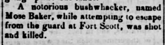
The prisoners were taken to Fort Scott, where he died the next fall. The Independent of Oskaloosa Kansas reported that “A notorious bushwhacker, named Mose [sic] Baker, while attempting to escape from the guard at Fort Scott, was shot and killed.” [Sept 26, 1863]
The Leavenworth Bulletin (Leavenworth Kansas) reported a more detailed description of his death 5 days prior, though it did not name him:
We learn that a rebel Captain was shot by a guard at Fort Scott last week while attempting to make his escape from the military prison. He was allowed to go down to a spring for the purpose of procuring waters and thought it an excellent opportunity to “procure” his escape from durance vile, and set the project on ‘fort’ by commencing the tallest kind of skedaddle. The guard was too sharp for him, however, and shot him dead. Eight balls went through him, which let sufficient daylight in to see the other world.
Leavenworth Bulletin, 21 Sept 1863
Sources
Schrantz, W. L. (1923). Jasper County, Missouri, in the Civil War. United States: Carthage Press.
The History of Jasper County, Missouri: Including a Condensed History of the State, a Complete History of Carthage and Joplin, Other Towns and Townships …. (1883). United States: The Printery.
Britton, W. (1882). Memoirs of the Rebellion on the Border, 1863. United States: Cushing, Thomas & Company.
Perry, L. J., Ainsworth, F. C., Lazelle, H. M., Moodey, J. S., Davis, G. B., Kirkley, J. W., Scott, R. N. (1902). The War of the Rebellion: A Compilation of the Official Records of the Union and Confederate Armies. United States: U.S. Government Printing Office.
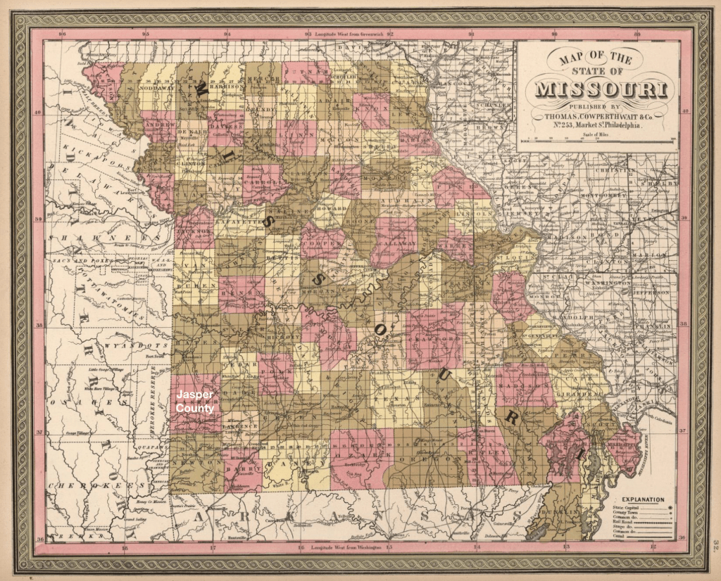
In 1850, Samuel and Jacob Rickner were living in Jasper County, Missouri in the southwest corner of the state, along the border of the Indian Territory that would become the Kansas Territory in 1854 and the state of Kansas in 1861.
1850 Map of Missouri by Samuel Mitchell | davidrumsey.com
Samuel was working the land as a farmer. His real estate was valued at $700 in the 1850 US Federal Census. He was living with his first wife, Permelia Baker, a widow with two older children, James and Nathan Cook, and their eight children. Enumerated after Samuel was his brother Jacob, a game hunter with a wife and children.
Land records (blm.glorecords.gov) show Samuel Rickner owned land east of Carthage in T 28 N and R 30 W, section 17. He purchased two parcels in 1844 and another parcel in 1852 and 1853, all in the same section. He also purchased parcels in section 9 and section 20, adjacent to section 17 to the northeast and south respectively, expanding his property beyond the original $700 value.
By 1857, Permelia had died, and Samuel remarried. In November 1857, the Justice of the Peace for Sarcoxie Township in Jasper County, Missouri “solemnize[d] the rite of matrimony between Samuel Rickner and Margaret E Reneau.
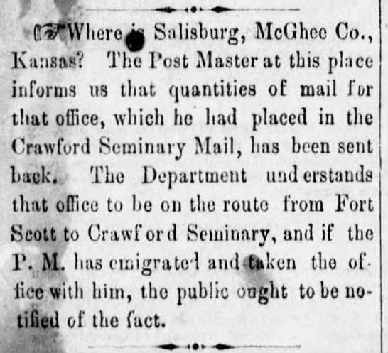
By 1860, Rickner has moved his family west, across the border, into the Kansas Territory. He is living in what was then called McGhee County in the Kansas Territory, near the post office of Crawford Seminary. Crawford Seminary was a post office on the mail route from Fort Scott and a mission for the Quawpaw Indian tribe.
The Fort Scott Bulletin | Fort Scott, Kansas | 24 Nov 1859, Thu | Page 3
Crawford Seminary had been established in the 1840s by a Methodist minister from Sarcoxie, Missouri, originally on Spring Creek in Jasper County. Five years later, they moved the seminary onto the military road from Fort Smith (Arkansas) and Fort Leavenworth (Northern Kansas), within Kansas Territory. It was closed when there was a measles outbreak in 1852. The purpose of the missionary was to convert the American Indians, specifically the Quapaw tribe.
The US Federal Government had forced the Quapaw tribes (connected to the Siouan family of tribes) to the Indian territory in 1834. French-speaking colonists had learned the Algonquian name for the tribe “akansa” and assimilated that into French to be Arcansas, which became the name for the Arkansas river and state.
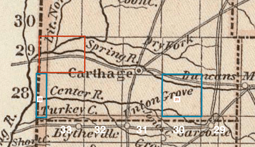
The map shows the geographical relationship between Fort Scott, the Quapaw Reservation, Shoal Creek, Jasper and Newton County.
1853 Map of Missouri by Samuel Mitchell | davidrumsey.com
In 1945, the Joplin Globe ran an obituary of Sarah Jane Gaither, the daughter of Samuel Rickner. It shares that she was born in 1844 near Willow Springs, five miles east of Carthage and that her father also homesteaded a farm on Shoal Creek, southwest of Galena [Kansas].
The biography of Christopher Rickner (Samuel’s oldest son) records that Rickner “came to Kansas when it was still a territory” and lived there until his death in 1861. The government began to sell the land in the 1850s to white settlers, and the while there had been earlier attempts by Euro-Americans to settle the land, the first white settlers came in 1856.
His son appears to have settled on that homestead near the Crawford Seminary Post office. The biography records that Christopher Rickner came to Cherokee County [McGhee Territory] in 1861 and settled in Garden Township, Cherokee County; he soon left for Missouri for five years and returned in 1866 where he stayed. He received his land from the government in 1870 in Cherokee County.
The excerpt from the 1902 Plat Book from Cherokee County shows the relationship between Rickner’s farm, Shoal Creek and Galena. The eastern edge of the excerpt is the state border between Kansas and Missouri.
Sources
Johnson, L. G., Johnson, L. G. (2009). Tar Creek: A History of the Quapaw Indians, the World’s Largest Lead and Zinc Discovery, and the Tar Creek Superfund Site. United Kingdom: Tate Publishing & Enterprises, LLC.
History of Cherokee County, Kansas and Representative Citizens. (1904). United States: Biographical Publishing Company.
“Cherokee County” on Community & Conflict, the Impact of the Civil War in the Ozarks. access from ozarkscivilwar.org