George L. Crookham | Abolitionist

George Lennox Crookham moved to the Ohio frontier in 1799 where he settled and worked the salt works. He was a self-educated man who “used to read and study by the light of the furnace at night” by the salt boiler. (Jackson Standard, 14 Jul 1855, p 2 | newspapers.com)

“Jack Oak College” Burned

In the community , he became a schoolteacher and “noted for the originality of his ideas and philosophic turn of mind”. (Jackson Standard, 29 Jun 1876, p 3 | newspapers.com)

His school was known as “Jack Oak College” (for he used Jack oak to build the school house) and even after his death the area was known as the Crookham School District.

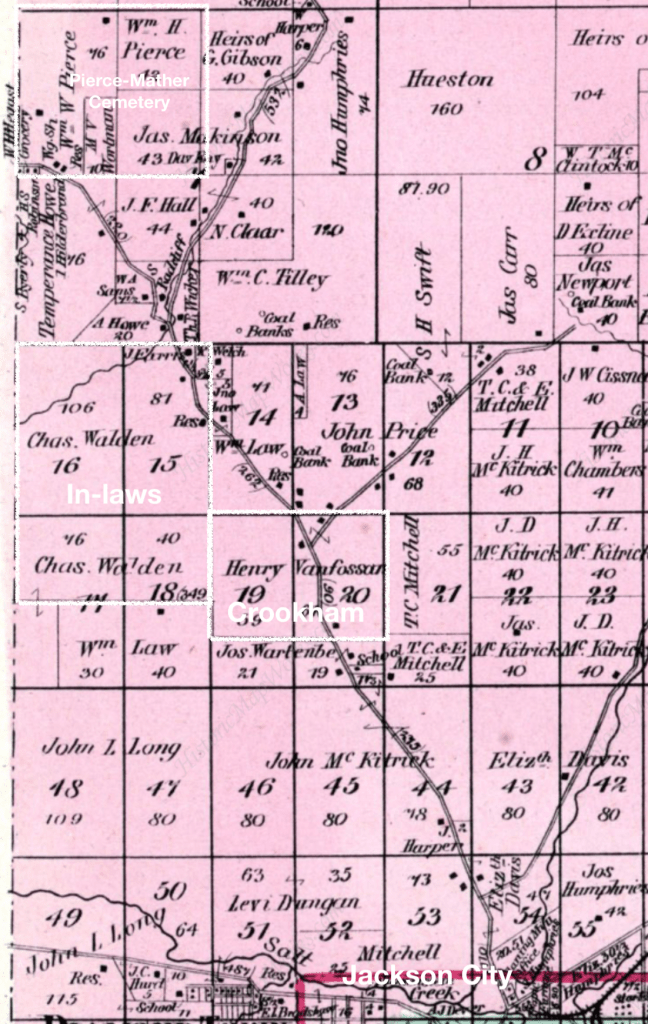
He had a private school house on his farm, two miles from town, on the Chillicothe road, wehre Henry Vanfossan now resides. There he taught his own and his neighbors’ children and in this little school house he kept his library, apparatus, and fine cabinet of natural curiosities, which he had been accumulating, collecting and arranging for many years.

Jackson Standard, 24 Jun 1876
Annotated excerpt from Lick Township Map from Jackson County 1875 Atlas published by Titus, Simmons, & Titus | historicmapworks.com

The same article describes how in 1836 “the slavery question was agitated in the county, and a very few persons, among them Crookham, Alexander Miller, Dr. A. W. Isham and a few others, took open ground against this sum of all villanies.”

The article doesn’t specify what “agitated” the question, however, 1836 was the same year that James Birney began the publication of Philanthropist, an abolitionist newspaper in Cincinnati which called for the end of slavery and equal rights for Black people. White supremacists in Cincinnati tried to have his paper banned, and twice destroyed his printing press. (Ohio History Central.org)

Additionally, in 1836, in Pike County, Ohio, a neighboring county to Jackson County, there was polarizing discord over the “slavery question.” Rev. Edward Weed, an organizer for American Anti-Slavery Society had been forced to leave by a mob headed by the town’s founder and wealthiest resident, James Emmitt. In response to Weed’s presence, a meeting of citizens was called. John Innskeep Vanmeter, a Whig, was a political leader of the group who were anti-abolitionists and pro-slavery. They sought to ensure the continued oppression of Black people and the enslaved. (Scioto Historical Society)

The pro-slavery crowd in Jackson County, Ohio burned Crookham’s schoolhouse and its collections “because of his extreme views on the questions of temperance and slavery”. (Biography of Judge J. A. L. Crookham). “It was well known who committed the arson, yet no attempt was every made to bring the perpetrators of this outrage to justice”. (Jackson Standard, 29 Jun 1879).

In the Standard History of the Hanging Rock Iron Region of Ohio published in 1916, the author claims his schoolhouse was burned shortly after Crookham with Reverend Powell (John Wesley Powell’s father), and W. W. Mather, noted geologist, invited Professor Williams of Oberlin to speak in town. On this occasion, a mob attacked the abolitionists and forced them to seek refuge in a “leading citizen’s” house. (p. 369) Oberlin was founded in the 1830s as a religious community and became a focal point in the abolitionist movement.

Underground Railroad

In his son’s biography, it described Crookham as “an old federal whig and assisted many a colored man to gain his freedom, his home being on the Underground Railroad of that day and his own son, Jefferson G, at one time drove a team that carried a load of these unfortunate people farther north.” He is listed in Siebert’s history of the Underground Railroad as a participant. “One of the underground railroads ran from the mouth of the Guyan through Jackson, and Crookham had charge of a local station. There was no difficulty in harboring runaways in the many rock shelters along Salt Creek and its tributaries… Through the aid of Crookham, runaways were conducted to the first of these houses located not far from his home, and no officer could ever trace them farther.” (Standard History of the Hanging Rock Iron Region of Ohio, p 370)

Guyan refers to Guyan Trace, a track used to move bushels of salt to the Ohio river. It had been a trail established by the Indigenous people, and used by Euro-Americans to transport goods. The description in the Standard History uses stations and furnaces to mark its location:

That trace left town where Nelson’s Furnace was located. It ran a south course and crossed the divide near where Irwin’s station now is. It then ran southward t the Adkins place, from there to old Joseph Price’s, crossed the Black Fork of Symmes creek near where old Henry McDaniel lived, then up long creek, and crossing Greasy Ridge rand own Trace Fork to the forks of Indian Guyan, now Scott town; then south or nearly so to Guyandotte [Huntindon, West Virginia]

p. 409

One of Crookham’s students, John Wesley Powell became a famed geologists who explored the Grand Canyon. In “Powell of Colorado”, the author describes how Crookham took Powell to explore Salt Creek Gorge to see the caves where self-emancipated Black people hid as they travelled along the railroad. Salt Creek Gorge is northwest of Jackson and formed by erosion from glacial waters.

He promised to show him a different kind of railroad. The two worked their way through Salt Creek Gorge, father than they had ever gone previously, until they came to a ravine where the overhanging ledges formed protected caves high above the stream bed. Suddenly, a black man, the first..Wes had very seen, crawled out of the caves. He was followed by another man, and then a third….

Indeed Crookham was familiar with this mysterious railroad be chase had had been in charge of the local station, and during his lifetime had assisted scores of runaway slaves on their way to Canada. The first of the refuge houses of Jackson was located close by Crookham’s farm and he had helped many to reach this station of safety and escape. A large colony of runaway [Black people] became established in the more inaccessible branch of Rock Run, Salt Creek Gorge, and West Pigeon Creek.

pg. 13, Powell of the Colorado.

Sources:

Andrew Feight, Ph.D., “Rev. Edward Weed & the Piketon Anti-Abolition Resolutions,” Scioto Historical, accessed May 29, 2022, https://sciotohistorical.org/items/show/107.

“James Birney,” Ohio History Central, accessed May 29, 2022, https://ohiohistorycentral.org/w/James_Birney.

“Judge J. A. L. Crookham”, Past and Present of Mahaska County, Iowa, by Manoah Hedge. accessed May 29, 2022, http://www.beforetime.net/iowagenealogy/mahaska/pastandpresentbook/ppcrookhamjal.html

A Standard History of the Hanging Rock Iron Region of Ohio: An Authentic Narrative of the Past, with an Extended Survey of the Industrial and Commercial Development. (1916). United States: Lewis Publishing Company.

Darrah, W. C. (2015). Powell of the Colorado. United States: Princeton University Press.

Sarah Millikin | Parents

Sarah Millikin, widow of Jonathan Walden, died in 1896 and she was buried in the Pierce-Mathers Cemetery in Jackson County, Ohio, with her husband and a Mrs. Jane Millikin. It is likely that Jane Millikin is her mother. The death date on the marker is 1868.

Census Record Review

A review of census records for Jane Millikin from 1830-1860 and related names highlight the following familial connections.

Jane’s husband most likely died prior to 1840, as John Millikin (age 20-29) is listed as the head of household in Liberty Township, Jackson County, Ohio in 1840. Living with John are three females, one age 50-59 (likely Jane) and two other adult women age 20-29, likely two sisters. There is a younger male age 15-19.

In 1850, Sarah Millikin is living with her husband in Lick County TWP and not with the Millikins. John Millikin, again head of household with wife and children, is also living with his mother, Jane, and his sister, Margaret, still in Liberty TWP. All of them, Jane, John and the inferred sisters, Margaret and Sarah, are listed as born in Pennsylvania.

In 1860, Sarah is living near Margaret Henry, a widowed seamstress. This is Margaret Mullikin, who had married James Henry in 1853 and who died in 1858. John and his family with his mother are still living in Liberty TWP.

A search of the 1830 census for Jackson County, Ohio, identifies “James Milligan” with a wife, and three daughters and one son. This is fairly consistent with the 1840 census, which has Jane living with four offspring. The gender of the unnamed child is different in each census; however the age and gender of Sarah, John and Margaret are consistent across the census records.

Military Warrant for Land

This inference regarding the family of Jane Millikin is confirmed by a Military Warrant issued to “Jane Milliken, widow of James Milliken or Milligan, Private in Captain Wallace’s Company, Pennsylvania Militia War 1812” (MW-0729-257; glorecords.blm.gov). The patent was issued in 1853 for 40 acres in 8N-19W NW1/4 of NW1/4 in Section 36 of the Ohio River Survey and assigned to John Millikin. This land is in the southeastern most corner of Jackson Township, along the northern border of Liberty Township, near Salt Creek.

The pay-roll of Capt. John Wallace’s company of Pennsylvania volunteers, attached to the First regiment, Second detachment, Pennsylvania militia, under the comment of Brig. Gen Richard Crooks (1812-1813) includes the name “James Millagen”. The pay-roll was signed at Indiana, Pennsylvania. (Pennsylvania Archives, 1880 p 496 | google books). Wallace was in the Fifth Company of the 1st Regiment under Joel Ferree. The company was drawn from Indiana and Armstrong Counties. Indiana County, Pennsylvania is in western part of the state, west of the mountains. Immediately south of it is Westmoreland County.

In 1820, a “James Milegan”– spelling similar to militia roll– was listed in Westmoreland County, Pennsylvania, with a wife and three children. The ages of the children are consistent with Sarah, James, and Margaret; however the genders are not. He is residing in Allegheny Township which is in the northwestern most corner, along the border of Armstrong County.

Preliminary Conclusions

This would suggest that Sarah is the daughter of James and Jane Milligan from Western Pennsylvania, information consistent with the census records. She was born prior to her father’s service in the War of 1812, and her siblings were born after her father’s service. They moved west in the 1820s to Jackson County, where her father sought land through a military warrant. He died in the 1830s and his widow and son worked the land, obtaining the patent in the 1850s.

Sarah Millikin | Ohio Bride

Sarah Millikin married Jonathan Walden in the winter of 1832 in Jackson County, Ohio. Their daughter, Mary Jane Walden, born the next fall, would marry Oliver C. Crookham (I) and migrate to Greenwood County, Kansas after the Civil War.

Sarah was born in 1810 in Pennsylvania according to the census records of 1850-1880. She died in 1896 and was buried in Pierce Mather’s Cemetery with Mrs. Jane Millikin, who had died in 1868 and her husband, Jonathan Walden who died in 1857. The cemetery is on land by Salt Creek owned first by W. W. Mather and later purchased by W. W. Pierce. Mather laid out the cemetery when his wife died in 1850 and deeded the cemetery to the town (History of Jackson County, Ohio) It is north of Jackson, off of Highway 35 on Pierce Mather Cemetery Road. Both Mather and Walden were Baptists and had founded the Baptist Church in Jackson County, Ohio.

In 1840, Jonathan Waldron is listed in the census living in Liberty Township, to the west of Lick Township, where they would move to by 1850. In 1841, he purchased land from the government as part of the Ohio River Survey. It was along the road southwest of Oakland. The 1875 map of Jackson County with the detail of Liberty Township shows the presence of Coal and Ore deposits on the Waldon land. (7N-19W, Sec 15, SE1/4 SE1/4).

Section 15 from Liberty Township Map

In 1850, Jonathan and Sarah lived in Lick Township, and were enumerated on the same page in the census as George L Crookham, who was the father of Oliver C. Crookham (I). The Crookhams had real estate valued at $3000 and the Waldens at $2000.

1850; Census Place: Lick, Jackson, Ohio; Roll: 698; Page: 283a | ancestry.com
[Annotated] County Outline Map from Jackson County 1875 by Titus, Simmons, & Titus | historicmapworks.com

Oliver and Mary were already married and living in Jackson Township, enumerated immediately after Lawrence Crookham, Oliver’s brother. Lawrence had real estate valued at $18,000.

By 1860, Sarah was widowed, and she was living in Lick Township, on land valued at $4000 with her children.

John Barkuloo | Dearborn County, Indiana


John Barkuloo had a name that nobody could spell. From Long Island, NY of Dutch descent, the record keepers of Indiana did their best to spell the unfamiliar surname. For consistency sake, I have settled on “Barkuloo” for when writing about the family. The records, though, and transcription of the records, will reveal much more variation.


Arrival in Dearborn County | 1810s

The “History of Dearborn and Ohio Counties, Indiana” (1885) records John Barkalow purchasing land in Logan Township, Dearborn County, situated in southeastern Indiana, along the Ohio border in 1815 and 1818. Both of these land entries were patented by an assignee, rather than Barkuloo himself in the BLM database. (Sec 12, T6N, R1W in 1815, and Sec 8, T7N, R1W in 1818, portions are not specified).

1820 Census for Logan Township, Dearborn County, Indiana | ancestry.com

Remarrying in Dearborn County | 1820s

In 1820, John “Barculoo” is recorded in the census for Logan Township, Dearborn County, Indiana. He is listed with his seven children and no wife. Catherine L., wife of John “Barkalow”, is buried in Bond Road Cemetery, located immediately north of Section 12 where John originally purchased land in 1815. While his wife is buried closer to the 1815 land, the neighbors on the census page suggest that Barkuloo was living nearer to the 1818 land. In 1820, he also had a letter waiting for him at the post office, which was advertised in the Indiana Oracle (15 Apr 1820)

County outline of modern-day Dearborn County, Indiana.
Sections from PLSS marked teal with Bond Road Cemetery marked.

John Barkuloo remarried in 1829 to Ruth Mayall. Robert Mayall is a neighbor in the 1820 census, he died in 1826. Robert Mayall was a wool carding manufacture.

On 18 and 25 November 1826, Ruth Mayall runs a notice as administratrix of his estate. (Indiana Palladium, p. 3; newspapers.library.in.gov) On 2 Aug 1834, the newspaper runs a notice of case before Probate Court regarding the settlement of debts in Robert Mayall’s estate. It names Ruth and John “Barricklow” and additional heirs, suggesting that Barkuloo married Robert’s widow.

Indiana Palladium, 2 August 1834 | newspapers.library.in.gov

The spelling was most likely influenced by a family of Barricklows that lived near Rising Sun, Ohio County, Indiana (directly south of Dearborn’s current borders). These Barricklows were involved in politics and owned a stoneware pottery factory and store, and even engaged in wool carding, like the Mayalls.

1830 & 1840 Census Records

1830 Census

In the 1830 Census, the enumerator for Logan Township roughly alphabetized the names, reducing our ability to glean information from neighbors. Both John “Barricklow” and Harmanus “Barricklow” are listed.

John has 3 children between the age of 5-9 in his household, suggesting that he married between the death of Catherine Lott in 1817 and his marriage to Ruth Mayall in 1829 and that all of his older children have left the household. The Dearborn County Courthouse burned in 1826, and it is likely records of the marriage burned in the fire. Some researchers have named “Sarah Angevine” as the second wife of John Barkuloo, prior to his third marriage to Ruth. Ruth is listed in his household (unnamed) as a woman between the age of 30-39.

The Angevine Family can be found in the 1820 census living in the Manchester Township of Dearborn County, which is southwest of Logan Township. James Angevine bought the entire section 5 of Township 6N and Region 2W (in a time when most men bought a quarter). In the Angevine Family Cemetery (located in the NW 1/4 of Section 2 (also purchased by Angevine) is the memorial for Sarah “Bartlow”. This supports the theory that that Sarah Angevine is the second wife of James Barkuloo. The Angevine family was also from the New York City area.

Map of Dearborn County showing relationship of Angevine land to Barkuloo land

1840 Census

By 1840, John was living in Miller Township, which was located near his original acreage and near the Bond Road Cemetery. He was no longer married to Ruth Mayall, yet had two small children in his household.


Barkuloo’s Children with Catherine Lott

John Barkuloo traveled to Indiana with his first wife, Catherine and the following identified children from Long Island, New York. Their baptisms are recorded in the Dutch Reformed Church records: Eliza Ann(b. 1800), Rachel (b. 1802), Harmanus (b. 1804), Henry, (b. 1806) Sarah (b 1808), and John (b. 1810)

Eliza Ann Barkuloo

Eliza Ann is not listed in her father’s census record of 1820, suggesting that she married prior to 1820. Unfortunately, in 1826 the courthouse in Dearborn burned down, destroying marriage records.

She married Silas Garrison (based on marriage records of a son); he is the grandson of Levi Garrison, who came to Ohio prior to 1800, settling in the Symmes Purchase between the Miamis before moving into Indiana. Levi Garrison had six children, including a Silas Garrison who is the uncle of Eliza’s husband. In 1820, the younger Silas is listed in the census for Dearborn County, with his wife and one male child.

She and her family ultimately moved to Wapello County, Iowa.

Rachel Catherine Barkuloo

Rachel isn’t listed in her father’s census record of 1820 either. She married David Miller (based on marriage records of a son).

David Miller, while listed in Logan TWP for 1830 and 1840, is not listed in the 1820 census, suggesting David and Rachel still lived at his family’s home. However, with 20 Miller families in Dearborn County and 5+ with a male and female between 16-25 years, it is difficult to ascertain which household exactly.

She and her family ultimately moved to Jackson County, Iowa.

Harmanus Barkuloo

Harmanus’s birth year of 1804 suggests he is recorded as the male child 10-15 years old in the 1820 census; he marries Rebecca Thorn in 1828, which makes it likely he was still in his father’s household in 1820. By 1830, he has moved out and set up his household, near his father’s home. He stays in Dearborn County until he moves to Minnesota during the Civil War.

Sarah Doryea Barkuloo

Like Harmanus, Sarah was likely listed in the 1820 census as the female between 10 -15. There is a marriage record for Sarah Barkuloo to William Garrison in Rush County, Indiana in 1831. William was the cousin of Silas Garrison, Sarah’s brother-in-law.

The Garrison family had originally purchased several lots in Dearborn County in the early 1810s. By the late 1820s, two of the Levi’s sons, Aaron and Samuel, had moved into Rush County, as well as Levi’s grandson and Silas’s brother, John B Garrison.

In the 1830 census, Silas Garrison has two adult women living in his household. The older one, age 30-39, is likely his wife who was 30. The other adult, was 20-29, which fits Sarah and suggests, that as she was living with her sister, she had occasion to meet with the Garrisons and their extended family in Rush County.

William and Sarah move to Wabash County, with several of William’s brothers and where William owns a tavern.

John Barkuloo, Jr.

It is unclear what happened to John Barkuloo, Jr. Born in 1810, he appears to be listed in the 1820 census as a male under 10. A John Barkuloo married Catherine Foster in Rush County, Indiana in 1834. The timing is consistent with his age. They had a son, James T. Barkuloo who died in Monroe County, Missouri; their names are listed on his death certificate and name Rush County as his county of birth. This suggests that John Barkuloo lived in Rush County. He has not been located in census records

Charles and Sophia Barkuloo

Unlike the first group of children born in New York, Charles and Sophia Barkuloo were born in the Northwest Territory.

Charles helps to put into sharper focus when the Barkuloo’s arrived in the Northwest Territory. The 1850 and 1860 census records put his birth year is around 1812 and he cites both Ohio and Indiana as his birth place, suggesting that his family arrived around his birth. He married Amanda Cox in Rush County in 1835 and then Clarissa Cox in Dearborn County in 1839.

Sophia’s census returns suggests a birth year around 1816 and again, both Ohio and Indiana are cited, confirming the information from the land purchase records. Sophia married Thomas King in Rush County in 1837 and is living in Wabash County, the same county as Sarah Garrison, her sister.

Summary of 1820 Census of John Barkuloo’s household

In the 1820 Census, he had seven children living with him: 4 boys and 3 girls:

Age Range in CensusEst. Birth YearsLikely ChildNotes
1 male under 101810-1820Charles*Born in Northwest Territory
1 male under 10 1810-1820JohnBorn in New York
1 male 10-15 years old1805-1810HarmanusBorn in New York
1 male 10-151805-1810HenryResearchers name a “Henry Barkuloo”, 1806-1827; no records regarding death have been located by me
1 female under 101810-1820Unknown
1 female under 101810-1820Sophia*Born in Northwest Territory
1 female 10-151805-1820SarahBorn in New York

1840 Census and the Barkuloo Children

Logan County Residents

In 1840, three of the children appear to still be living near the 1818 purchase.

Annotated paged from 1840 Census | Dearborn County, Indiana | ancestry.com
  1. Harmanus married Rebecca Thorn in 1828; she may be related to Stephen Thorn, who patented land in the same section as Barkuloo. Her gravestone states that she is the daughter of S & H Thorn.
  2. Listed above Harmanus, is Charles Bartlow, possibly a mis-rendering of a Barkuloo, as he married Clarissa Cox in 1839, and he is listed immediately under Daniel Cox, and other Coxes live nearby.
  3. Likewise, on the second page, is David Miller living next to William Chappelow, who with Miller, were assignees of land patented by the Judds, who were neighbors of Barkuloo in 1820. David married Rachel.
summary of Levi Garrison’s Family with connections to Barkuloo Family

Map will show modern day boundaries, land purchases and cemeteries. Click on sidebar for available layers.

George Vanslyke | Model T & Pie Suppers

George Vanslyke (1887-1967) purchased a Model T in 1927 from the Carter Hardware Store in Stella, MO. 1927 was the last year that Ford produced the Model T.

Our first car was a 1927 Model T Ford- a demonstration model which the Carter Hardware Store at Stella, which had a Ford agency, sold Dad. I remember it costing $600, George says it was more like $365. Anyway Dad bought it at town one day and Mr. Carter drove it out home for him and gave him a driving lesson in the pasture west of the barn.

from the typed autobiography of Irene Vanslyke

Model T’s were so popular during their day, that Henry Ford chose not to engage in national advertising, though local dealers would advertise stock.

The only accident I remember Dad having with the car was one night when we started to Hazle Green to a pie supper. It was the first time Dad had driven the car at night and when we met another car the lights blinded him and they ran together. No one was hurt and the cars were both ok to drive. Probably both drivers were going 10 to 15 miles per hour. Mom who knew all the old superstitions had put her dress on the wrong side out, and had to change it when she getting ready to go and since that was a sign of bad luck I don’t know of her doing that ever again. If she put on a dress wrong side out she’d just take it off and wear a different one.

from typed autobiography of Irene Vanslyke

The paper advertised a pie supper at Hazel Green in 1928. Hazel Green was the one-room schoolhouse that Irene attended for the first four years of her education.

The Neosho Times | Neosho, Missouri | Sep 20, 1928 | Page 8
The Neosho Times | Neosho, Missouri | 27 Sep 1928 | Page 4

An Ozark box or pie supper presented to the uninitiated a deceptively simple format. When a community wanted to raise money for some worthy cause, they often decided to do so by means of a box or a pie supper. The women and girls baked pies or prepared box lunches, and everyone gathered at the local schoolhouse, where the pies or boxes were auctioned off to the men and boys present. Purchase of the pie or box brought with it the companionship of the girl who had prepared the item. The proceeds of the evening went to the chosen cause.

“Box and Pie Suppers”, Ozark Baptizings, Hangings, and Other Diversions, Robert K. Gilmore 1990

Pie-suppers were a cornerstone of Ozark tradition. They were used as a way to raise funds and build communities and were often used to fund the schools. Local schools were often underfunded due to low taxes. In her handwritten biography, Irene describes that her father wanted to consolidate schools despite the community’s opposition fearing higher taxes. The book, “Box and Pie Suppers”, describes how the funds from a pie supper would supplement a school with the “extra things that were necessary for good teaching. So the more progressive teachers would have pie suppers or box suppers, with a program, of course, to try and raise some money for books or extras.” (p. 109)

In 1933, The Neosho Times ran a line of news from Wanda (a town near George Vanslyke’s farm) that “The school is serving hot lunches now. The equipment was purchased with pie supper money”. In 1930, the newspaper ran another piece describing the pie supper at Northview: “The children of the school gave a program before the supper and store. The school house was crowded to overflowing. Proceeds will be used for school equipment.”

Irene Vanslyke | Joplin Junior College

Irene Vanslyke (1920-2012) attended Joplin Junior College from 1938-1940 and earned an Associate’s Degree in Education.

Joplin Junior College from 1939 Yearbook | ancestry.com

The college was a Junior college which was started the year before I went. The first year classes were held in the HS building but the year I started they had bought an old school building which they used for several years.

from handwritten autobiography of Irene Vanslyke
Diploma for Irene Vanslyke

At that time in MO, one only needed 60 hrs to get a teaching certificate. However, in ’40 when I graduated with an AS degree school teachers were more plentiful than jobs and school boards just weren’t hiring people with no teaching experience

from handwritten autobiography of Irene Vanslyke

I’d had early ambitions to be a lawyer but by the time I finished HS I knew I’d be lucky to get to go to college enough to be a teacher. My parents were not financially able to send me to college but several things combined to make it possible. A junior college had been started in Joplin, Mo. where I had an aunt living, and I received a scholarship which paid for my first two years tuition. My aunt did not charge me any board and I was able to get a job for the summer between HS and college. I stayed with a family where the mother recently passed away and I did light housework and acted as a companion fo the girl who was about my age. I made $3 a week and since I had no expenses was able to buy most of clothes to start to college. My second year I worked Fri, Sat, + Sun nites at a little lunchroom. I received one dollar per nite and had to pay for having my uniform (which was furnished) laundered.

from handwritten autobiography of Irene Vanslyke

Irene doesn’t name the the lunchroom she worked for and in her yearbook, the following advertisement was run:

from 1939 Joplin Junior College Yearbook | ancestry.com
Joplin Globe | Joplin, Mo | 9 Jan 1944 | newspapers.com
Possible uniform for Irene

During my two years at Joplin Jr. College I made some good friends. One of which I still keep in touch with. We were both in teacher training courses and after we became acquainted we discovered that her grandfather and my grandmother were brother and sister.

from handwritten autobiography of Irene Vanslyke
Picture likely from Summer of 1939
Jean Ward, Irene Vanslyke, Mary Allen, Marjorie See, and Orva Allen (L to R)

At college, Irene joined the Pi Alpha Gamma sorority.

1939 Yearbook for Joplin Junior College | ancestry.com

1939 Yearbook for Joplin Junior College | ancestry.com
Irene Vanslyke is in the second row at the end

Thomas Relf | Great Plains Roamer, pt 1

Thomas Relf (1857-1940) was born in Indiana and lived in Missouri, Kansas, and Nebraska prior to 1900.

Norton County, Kansas | 1879

In 1876, he married Sarah C Peniston in Madison County, Indiana. Shortly after their marriage, they migrated to Norton County in northwestern Kansas. It is the fourth county from the border with Colorado, and sits along the Nebraska border.

1879 Railroad and Township Map of Kansas | davidrumsey.com

The biography of their son, Josiah Frank Relf, (History of Richardson County, Nebraska, 1917, p. 1042) records that he came to Edmond, Norton County in 1879.

Re-creation of hand drawn map by Caryl Hale for crossroads.humanitieskansas.org

Settlement

Edmond is in the southeastern part of the county on the Solomon river, just east of Sand Creek. It was platted in 1879, the same year that the Relfs came to Kansas. It advertised its quick growth in the Norton County Advance:

Norton County Advance | Norton, Kansas
25 Dec 1879, Thu  |  Page 3

The building of a frame house was newsworthy as many of the settlers built homes with sod due to a lack of timber.

Norton County was established in 1872, and the Norton Courier in 1880 describes the immigration as starting in 1878:

The first genuine settlement in the county was in 1872, in Solomon and Center townships but the county did not begin to fill rapidly with settlers till the spring and summer of 1878…In 1878 nearly all the best vacant land in the county was taken, and the next year sa as much immigration, so that at the close of 1879 but little vacant land was left, except such as was too rough to suit.

Norton Courier (Norton, Kansas) | 15 Jul 1880 | page 1 | newspapers.com

An article in the Dodge City Times describes the arrival of a large settlement of people from Indiana. The counties mentioned, Montgomery, Clinton, Tippecanoe, and Fountain west of Madison County. This was shortly before the Relfs came to Kansas.

Dodge City Times | Dodge City, Kansas | 21 Sep 1878, Sat |  Page 1 | newspapers.com

The 1880 Census for Norton County lists the Relf family settled nearby to other families from Indiana. Among these families, George Hilligoss was listed in the Madison County 1870 census and may be known by the Relf family prior to migration. It is likely, based on the birth dates of his Hilligoss’s children, that he arrived in the 1878 migration group.

Drought

The Relfs arrival in 1879 was untimely based on indications from editorials in the newspapers. While real estate agents advocated for immigration and newspapers promoted western Kansas, it seems that 1879 & 1880 were difficult years for farmers who weren’t used to the semi-arid weather of Kansas.

We then looked for the heaviest immigration in our history. Lots were contracted for in all the towns and preparations commenced for building in the spring. As the months rolled on and the dry weather continued fears began to be entertained for the crop of all grain. When this became a certainty of failure the farmers immediately proceeded to re-seed to spring grain, which from the same cause also failed, and the ground was then wanted to corn and other crops. Still no rain came and not until the 13th of the June was the ground gladdened with a genuine soaking. Meanwhile many of the weak-kneed had taken their departure, asserting that “they never did believe in Kansas, anyway” but in nearly every instance taking an extension to prevent someone else from taking the land on which they pretended to think so slightly. With them had gone many prudent persons who thought the country was all right, but that they could do better elsewhere this season.

Norton Courier (Norton, Kansas) | 30 Dec 1880 | page 4 | newspapers.com

In 1886, the Western Kansas World newspaper published in Wakeeney Kansas cited an undated Norton Champion piece that paints a picture of extreme poverty and hunger:

Only five years ago [1881] we had occasion to visit a neighborhood a few miles from here [within Norton County]; we remember that scene of poverty. There was a woman grinding corn in a coffee mill; two small children at the stove, jealous of each other for watching a nubbin of corn on the fire made of buffalo chip; and younger one at the ragged mother’s knee crying to be nursed. … If hunger asked to be incarnate, it would have haunted the frame of that mother. … Scurvy was in their teeth and rotten gums, for not a green plant grew in the garden to forestall it. The cornstalks withered long before under a scorching sun, or their sweet juice would be food and manna.

The editor of the paper continues with his own response describing how the “It was during the ordeal of 1880 that you witnessed the ghastly blight which overtook the pursuit of agriculture in western Kansas. The terrible extent of that blight lay in the immigration 1878-9, having come here, virtually as a whole, to follow farming. It followed by reason and reality that the failure of the farming community meant general suffering. Perhaps nearly all who felt it possible to do so left the county.” Those that stayed shifted from “straight farming” to raising livestock and raising crops to feed the stock.

The Relfs left Norton County in 1880. They returned east, headed toward Missouri.

DeKalb County, Missouri | 1880

In Norton County, the Relfs had lived near John O’Bright and William Reedy, who originally from Indiana, had migrated and settled in Andrew County, Missouri prior to coming to western Kansas. They likely told the Relfs about land in northwest Missouri and when the Relfs left western Kansas, they migrated to DeKalb County, to the immediate east of Andrew County, as related in the biography of Josiah Francis Relf (p. 1042).

Johnson’s Missouri And Kansas | 1865 | davidrumsey.com
excerpt from Northwest corner shows Andrews county on the Missouri River with DeKalb to its east

It’s unclear how long they stayed in DeKalb; by 1885 they were recorded in the Kansas State Census in Neosho county. Josiah, their third child, was born in Missouri in 1881, and their fourth child (listed in the census) was born in 1884 in Kansas. This suggests they stayed between two to three years before migrating again.

Neosho County | 1885

If Relfs were pushed from Norton County, Kansas to more fertile land, they were likely pulled to Neosho County by family.

Neosho County is in the southeastern part of the state.

1879 Railroad and Township Map | davidrumsey.com

Aunts and Uncles

Thomas Relf married Sarah C Peniston in Indiana in 1876. She was the granddaughter of William and Sarah (Barkeloo) Garrison who lived in Wabash County, Indiana. The Garrisons died in the 1850s, leaving their children orphans. The older children married in the 1850s.

Hannah, the eldest daughter, married Isaac Peniston, a farmer in Madison County, where her grandfather lived. In the 1860 census for Madison County, Isaac was a farmer with land worth $2000. By the 1870s, he isn’t recorded in the census. Isaac and Hannah took in her younger siblings, Oliver and Eliza.

Samuel, Sarah’s uncle, married Sarah and continued to live in Wabash County. In 1880 he had migrated to Grant County, Indiana, before migrating to Neosho County, Kansas, where he died in 1883. The Osage Mission Journal reported his death as the result of heart disease. He left behind his wife and children. His farm was advertised for sale to satisfy debts in his estate by his administratrix, Susan Garrison (Erie Record, 27 Jul 1883, p 4). It was described as located in T28, R 18, S 18 & 17, that is Canville Township. His land straddled the road north out of Earlton. He is buried in the Earlton Cemetery. His wife returned to Grant County, dying in the soldier’s home in the early 1900s.

Catherine, Sarah’s aunt, married George Riley in Madison County. It was at their home in Madison County, that Sarah and Thomas were married. They moved to Neosho County in 1880, according to the obituary of George Riley. Catherine, George’s wife, died in 1885 from a fall. She had been on a ladder placing jars of peaches on a high shelf.

undated Family Portrait of George Riley and Catherine Garrison | ancestry.com
Chanute Blade | Chanute, Kansas | 24 Sep 1885 | P2

The Kansas State Census lists the Rileys prior to Catherine’s death on page 8. On the next page, the census lists the Relfs. Thomas Relf is working as a mason, not a farmer, according to the census. The Chanute Blade in 1885 (19 Feb 1885, p. 4) reported out the Tioga Township’s Treasurer Report which included the details that Mr. Relf had earned over $60.00 working on the bridge. By 1887, The Chanute Blade (28 Jan 1887, p. 3) reported that Thos. Relf would be farming G. W. Riley’s farm in the coming season. His farm was located near Urbana, about 4-5 miles east of Earlton, and on the border of Townships.

1885 Kansas State Census | ancestry.com
showing Thomas Relf family, profession as mason, and that they migrated from Missouri, with the exception of their youngest who was born in Kansas

The Relfs stayed just a few years and then settled in Nebraska by 1888.

George Akin Vanslyke | Farmer

George Akin Vanslyke (1887-1967) was a farmer in Newton County, Missouri. He owned 80 acres of land near Indian Creek in Benton Township.

Granby RR was our mailing address but the farm was 15 miles or so from Granby and only five plus to Stella where my family traded and where we went to church and where I went to school from grade 5 until I graduated from High School.

from written memories of Irene Vanslyke, George Akin’s daughter.

He had purchased the land into two lots. The first forty were bought prior to his marriage and he purchased the second 40 acres around the time of World War I.

1930 Plat Map of Benton Township, Newton County, Missouri

Farmhouse

Wedding photo of George Akin Vanslyke and Claudia Almeda Vanslyke

He built a house on the first forty acres prior to his marriage to Claudia Almeda Lewis, who he “courted” for five years. He lived in the smokehouse while he built the home. The family stored meat, lard, and other things in it during Irene’s childhood.

The house which had been built was one and three-quarters stories with two rooms downstairs and room for two which were never completely finished upstairs. I can just barely remember living in the two rooms as more rooms were added around 1926 or 27.

from written memories of Irene Vanslyke
dated June 1929, “Grandpa Van’s House”
Likely taken by Claudia Almeda Lewis Vanslyke. Irene describes her mother purchasing a box camera in the 1920s.

The picture, dated 1929, would have been most likely after the addition, as Irene notes in her memories it was completed prior to her sister’s death in 1828. “The addition contained a kitchen, dining room, a pantry and closed porch on the north end and an open porch on the south end. Of the two original rooms, the south one became a living room and the north one a bedroom”. George Vanslyke got Ernest Link, a carpenter who lived a mile and a half away, to help him build the addition.

I do remember eating in the north room which was the kitchen. I can sort of remember the arrangements of furniture in the kitchen which included a cream separator which set by the west door.

from written memories of Irene Vanslyke

Farming

George had two mules, Kate and Jack, which he used for farming, because they were “smarter and stronger” than horses. His father, John Harrison Vanslyke, had “specialized in raising horses and mules” (The Story of Stella, Pioneer Town of Newton County, Missouri). While Irene and her sisters were not expected to engage in team work, Irene’s younger brother George did.

Picture from Joplin Public Library | ca. 1915 novelty postcard from Newton County, Missouri

When George was old enough to start going to the field with a team Dad always said Jack would go where he was suppose to and all George had to so was follow.

from written memories fo Irene Vanslyke

At times, prior to the Great Depression, George Vanslyke hired off and on a man to help him with the farm work. “Sam Hance lives in a shack which he built for himself just west of the northwest corner of our west forty acres.” Irene remembered him as an “old” man with gray hair and whiskers. He had had a breakdown after his wife died from a long illness and after his recovery at a hospital, lived near the Vanslyke’s working for neighboring farmers. He would eat lunch with the Vanslykes when he worked for them. He brought candy from the grocery store to give to the children. By the time of the depression, George Vanslyke had a young son, George Jr., who could help, and he could no longer afford a dollar a day for hiring him.

Threshing

In the summer, the neighbors would cooperate to thresh the cut and shocked grain. “No one in our immediate neighborhood had a threshing machine so the men would get together and get someone from of the surrounding communities to come threshing each farmers grain in turn.”

Picture of Robert Lee Lewis (father-in-law of George Vanslyke) who owned a threshing machine with a neighbor. They threshed the grain crops from the mid 1890s to the 1920s, prior to Irene Vanslyke’s memories.
Picture from Lest We Forget Our Lewis-Hardy Heritage by Jewell Lewis Campbell, 1982

Irene describes the threshing process as follows:

The wheat would have been cut with a horse drawn binder which cut the wheat and tied it with binder twine into bundles. These, men would place the bundles on their butt ends in shocks of eight or ten bundles. One or two bundles would be bent slightly in the middle and placed on the top of the others to held shed any rain that fell.

Other than the one or two men which came with the machine, Dad would usually have three farmers with wagons equipped with hay frames to haul in the bundles and at least two wagons with grain tight beds to haul grain to the barn. Each wagon which hauled the bundles would have a driver and someone to load on the bundles which were pitched up to them by two or three men working in the field.

This usually added up to twelve or fifteen or more men and boys to be fed at noon at whatever farm, they were working.

from written memories of Irene Vanslyke

In addition to wheat, George grew corn and tobacco in his fields. He had apple and peach orchards and a vegetable garden tended to by his wife and children. In Lest We Forget, a cousin describes visiting the farm and the bee hives he kept under some apple trees.

Several years I earned money by picking worms off Dad’s tobacco plants. I hated the job. Sometimes I carried a little can of keorsene to drop the worms in. Sometimes I’d pick them off with two sticks, drop them on a rock, turn my head and squash them with another rock. When he cut the tobacco plants, he’d tie them in bunches and hang them in the barn loft. One time Aunt Bess, Dad’s youngest sister was visiting and I heard her ask Mom, “Does Doc [George] have any home grown tobacco?” Mom told her where it was and she went to get some. I know she chewed tobacco, but I thought she was pretty bad off to chew that!

from written memories of Irene Vanslyke

During the Depression, Irene describes how in the dry summers in the early thirties:

Dad would wait until the fall rains started and plant turnips. Everybody ate turnips! We chopped them up raw for the chickens and the cows. Dad cooked them in a big black kettle outside for the pigs and we at them almost everyday. For a long time, I didn’t like turnips.

from written memories of Irene Vanslyke

Andrew Van Slyke | Gone to Texas

Andrew Van Slyke chased the frontier. Born in New York in 1797, he first went to Illinois, where he met and married his wife, Electra Norton in 1824. Leaving the Northwest Territory in the 1830s, he traveled with his family to southwest Missouri. Then in the early 1840s, he moved south into Arkansas and then finally, gone to Texas prior to 1848 to claim land provided to settlers as part of what would be called the Peters Colony.

Excerpt from A map of the Indian territory : Northern Texas and New Mexico, 1844 | David Rumsey Collection
Markups done by the blog author

The lands are pretty equally divided between woodland and prairies, with a gently undulating surface, and is interspersed with rivers, rivulets, and fine springs, which afford, at all seasons of the year, a superabundance of the purest and most wholesome water. The forest trees consist principally of white, post, and Spanish Oak, pecan, cottonwood, ash, elm, black walnut, and holly, affording an abundant supply of timber for fuel, building and all agricultural purposes.

The Arkansas Banner
Little Rock, Arkansas | 08 Jan 1845, Wed  | Page 3
The Register of the Kentucky Historical Society | jstor.com

Peters Colony

The Peters Colony was established under the Spanish system of empresarios. The leaders of the colony were granted the right to recruit and attract settlers to the “vacant lands of the Republic.” The lands were between the Brazos and Red River, and included the “celebrated Cross Timbers” along the upper Trinity River. Set up during the Republic of Texas, the leaders of the colony were granted a large swath of northern Texas and they advertised heavily in Illinois, Missouri, and Arkansas for settlers. Settlers from Arkansas were advised to come to Fort Smith and then to Fort Towson and from there to Inglish’s Fort. (Arkansas Banner, 8 Jan 1845)

Military Road

The road from Fort Smith to Fort Towson passed through the Indian Territory, where the US had removed several Indian nations from the east. It was built in the 1830s and connected frontier forts. It was approximately 145 miles long. A letter to the editor in 1839 extolling its virtues described it as a “veritable turnpike” with the assurance of “an excellent road at all seasons.” (Weekly Arkansas Gazette, 10 Jul 1839)

Fort Smith was established purposely to enforce US control over the Indian nations: the local Osage Indians and the Cherokee who had been forcibly resettled in the Indian Territory as well as the resettled Choctaw, Seminole, Chickasaw and Muskogee Indians. The frontier forts were established by the US War Department after the Black Hawk War when the resettled nations of Fox and Saux had tried to return to their ancestral lands in what the US claimed as Illinois.

Fort Towson was also established in the 1820s to serve as an outpost between the US and then Mexico, and later the Republic of Texas. During the Mexican War, it served as a staging post. It was abandoned in 1854 as the frontier “moved” west.

Coffee’s Station and Inglish’s Fort

Coffee’s Station was on the Red River, and was a trading post established by Holland Coffee in the 1830s. The trading post, along the Red River, was a place where Indigenous people and Anglo-Americans exchanged goods, the Indigenous people bringing furs for rifles, ammunition and guns. Later, in the vicinity of his post, Coffee established the town of Preston.

Replica of Fort Inglish in Bonham, Texas | The Lyda Hill Texas Collection of Photographs in Carol M. Highsmith’s America Project, Library of Congress, Prints and Photographs Division.

South of Coffee’s Station, was Inglish’s Fort, another military outpost on the Frontier. When the land was organized by Anglo-Americans into Fannin County, the settlement was renamed Bonham and established as a county seat.

1852 Arkansas, Oklahoma, and Texas | davidrumsey.com

William Garrison | America, Liberty, Wabash

William Garrison (about 1810-1858) with his brothers, helped to establish a small Euro-American town in Wabash County, Indiana in the 1830s.

A series of treaties in the early 1810s and 1820s displaced the Miami and Delaware peoples, allowing Euro-Americans to settle Indiana, migrating from the southeast border of Ohio farther north and west to the Wabash River. The treaties reduced the amount of reserved lands for the Indigenous people over the three decades: the Miami were confined to a small reserve in the north and the Delaware were removed to west of the Mississippi. The Garrison family was at the front of the encroachment, moving from Ohio, to Franklin County, to Rush County before establishing their town in Wabash County.

Childhood Migration

William Garrison was a middle son of Samuel Garrison, who had six sons. Samuel Garrison, born in New Jersey, had migrated with his family to Hamilton County, Ohio in the 1790s. Originally settling on lands purchased by a NJ land speculator called the Symmes Purchase, Samuel grew up between the Miami Rivers near what would become Cincinnati , Ohio, and near the southeast border of Indiana and Ohio.

In 1804, while still living in Hamilton County, Samuel married Hannah Goff, the daughter of another immigrant from New Jersey. Their oldest son, Elihu Garrison, was born the next year and in 1810, William was born shortly before the family moved from Ohio to Indiana.

In 1811, Samuel purchased, on credit, land located in Franklin County, Indiana, receiving his credit volume patent in 1817 from the US Government. Franklin County was directly across the border in Indiana. The Indigenous people, the Wyandot and Delaware had been displaced by the Treaty of Greenville in 1795, which included the sliver of land in what became Indiana along it’s eastern border. (History of Franklin County, glorecords.blm.gov)

The 1820 Census shows that Samuel Garrison lived near his brother-in-law, John Goff, in Franklin County. ( ancestry.com) They lived in the northwest corner near Laurel in Posey Township. There is a creek called Garrison Creek along which runs the Garrison Creek Road. The History of Franklin County describes how the early settlers established block-houses for “protection”, as they settled the lands of the Indigenous People.

At this time, the land beyond Franklin had yet to be surveyed by Euro-Americans and was where the Delaware were living. In the 1700s, with the arrival of the Euro-Americans in what became New Jersey, the Delaware had been pushed west and had settled in this part of Indiana, only to have Euro-Americans emigrate from New Jersey into Indiana, and further reduce their lands. John Goff is said to have traveled into these land to sell whiskey to the “Indians who still lived there”. In 1818, the Treaty of St. Mary’s displaced the Delaware again, and the land was taken for Euro-American settlers. The land office opened in 1821, and Samuel Garrison was an early purchaser.

1817 Map of Indiana | David Rumsey Collection

In 1821, Samuel purchased two plots of land in Rush County, Indiana. Samuel was still living in Rush County in the 1830 Census, presumably William was still living with his father, as he married Sarah Barkuloo in 1831. (glorecords.blm.gov; ancestry.com)

America, Liberty Township, Wabash County, IN

By the 1830s, the Rush County was no longer the edge of Euro-American established counties. In 1835, Samuel Garrison, and one of William’s brothers, Elihu, purchased land in Liberty Township, Wabash County from the government. His other brother, Jeremiah, also purchased land in 1836.

Excerpt of 1861 Map of Wabash County, showing America in Liberty Township, the plank road and land owned by Garrisons | loc.gov

The land they purchased was about halfway between La Gro and Marion, two trading towns in Indiana. In the 1830s, one of the only state roads was between Marion and La Gro, which was located on the Wabash and Erie Canal. As a result, the land the Garrison’s purchased was ideal to become a waystation for the traders, and in 1835, Elihu Garrison platted the town, America, in Liberty Township. It is reported that as many of 100 teams carrying grain would come through America as they traveled north to the Canal.

Elihu Garrison owned one of the first stores in America, called Garrison Bros. and William Garrison was the first hotel owner and tavern keeper, while also being the Justice of the Peace.

1861 Map of America by Skinner | loc.gov

The death knell came however, when the railroad chose a different route, bypassing America for Ashland, and with that the trading teams no longer traveled through America. William Garrison died in 1858.